20151116

社会と情報 62: 戦った報道 19


< 1.日露戦争の凱旋 >

今回は、1900年代から1930年代、明治末期から昭和初期にかけての国民の窮状を具体的に見ます。


三つの時期について窮状を見ます


< 2. 傷痍軍人 >

1900年代を中心に 文献1.
日清・日露の戦役が世の中を変えた。

廃兵(傷痍軍人)
日露戦争(1904、05年)によって、死傷病者は出征兵士の49%、46万に上った。
当時、人口4600万人、就業者2500万人の66%が農林業従事者で農家数540万戸であった。
特に農家の場合、彼らは主要な働き手であったので、その家族は路頭に迷うことになる。

苛税
国民総生産に占める全政府支出は1890年に11%であったが、1900年19%、日露戦役以降の1910年に38%に上昇してから、1920年25%、1930年38%となった。
1910年、国の一般会計歳入の内訳は、直接税の所得税・営業税が8.5%にしか過ぎなかった。
地租税11%と残り間接税の類80.5%が多いため、低所得層(庶民と農民)の負担が大きく、益々生活は苦しくなっていく。 注釈1.
累進性の無い税制、間接税中心の当時の税制は富裕層や企業には有利だった。 
これは当時の選挙民は一握りの富裕層だったので直接税導入が猛烈な反対に合い困難だったことによる。

この上、戦時公債の引受、「愛国心」を計られる半強制的な軍資献納金が追い討ちをかけた。
その結果、税金を払えないことによる財産の差し押さえは1900年代の10年で約10倍に増加した。


< 3. 村の身売り相談 >

1920年代前半を中心に  文献2.
第一次世界大戦の好景気の反動による戦後恐慌が世の中を変えた。 

農民の困窮
1922年頃、自作農家で32戸中11戸、小作農家で35戸中14戸が、赤字に陥っていた。
小作人は小作料と高利の借金に喘いでいた。
農民は寄生虫やトラホームに罹患し健康者は1割しかいなかったし、小学児童の弁当の副食は8割が梅干しだけであった。
こうして小作争議は1918年に全国で256件であったのが、1926年には2751件と膨れあがった。

農家の苦境の背景に何があったのか。
1910~40年の自作農は約30%に過ぎず、他は小作(一部自作も含む)であった。
またこの時期、米の反収が伸びない上に、1920年の戦後恐慌から1930年の間に米価は60%下落した。
この間、消費者物価は26%下落した。
1918年の米騒動以降1930年代前半までに、朝鮮米の徴発量は日本の産出量の約4%から14%に増え、昭和東北大凶作(1931~1932年)では不足分の7割を賄った。
しかしこれが日本の長期米価低下を招き、朝鮮半島の人は40%もの消費減に耐えなければならなかった。
彼らは満州に脱出するか、満州からの稗や粟でしのいだ。

もっとも、第一次世界大戦の好景気では、米価の高騰で農村は潤ったこともあった。
同時に、都市部では大正デモクラシーを謳歌し、労働者の賃金は上昇し、1920年代前半はまだ賃金水準が維持されたので恐慌の影響が少なかった。
むしろ都市部ではインフレ時に苦しむことになった。


< 4. 昭和恐慌、銀行の取り付け騒ぎ >

1930年代前半を中心に 文献3.
1923年の関東大震災、1927年の金融恐慌、1929年の世界大恐慌、1930年の昭和恐慌が続き社会は悪化の一途を辿った。

失業
企業の利益率は半分になり、賃金も2割減となり、会社の倒産が相次ぎ、賃金の不払いも増加し、大量解雇が発生した。
失業者は1930年から増え始め、31年に280万人、失業率8.9%でピークに達した。
労働争議は1925年に全国で293件だったのが、1931年998件とピークを迎えた。
この膨大な失業者のうち、工場労働者の約4割、鉱山労働者の約2割が帰農した。
ただでさえ貧しい農村に人が溢れ、困窮は極限に達した。
こうして農村部で人口過剰が問題となり、移民が説かれた。

農村の窮乏
都市部の購買力減はさらに農作物の価格を1929年から31年かけてさらに約60%低下させた(32年にかけてほぼボトム)。
さらに1931年、34年に東北・北海道が凶作に見舞われ、自作農で60%、小作農で75%が赤字農家に転落した。
税金が納められず、土地や収穫物を差し押さえられる農家が続出した。

こうして昼食抜きの児童が増え、東京へ娼婦として売られる娘が続出した。
1934年の身売りは約2万人で、娘を一人売ると親は約1年分の所得を得ることが出来た。
小作争議はこの年に更に最大を更新し6824件となった。


< 5. 所得格差 >
解説: 日本(赤線)は明治から太平洋戦争が始まるまで所得格差は高いままだった。
ドイツ(青線)では第一次世界大戦以後の社会主義政権で所得格差は是正されたが、ヒトラーの独裁が始まってから所得格差が急増したが、それでも日本よりもましだった。


まとめ
満州事変に至る約30年間の庶民の困窮状態を見ました。

この間、農家は日本の一人当たり実質成長1.3倍(注釈2)の経済発展から取り残され、さらに悪化し、豪農と貧農の格差も開いていた。
一方、都市と工業は大きな発展を遂げたが、第一次世界大戦の好景気と戦後恐慌を経て、経済格差が広がった。
労働者では熟練度や企業規模(産業の二重構造)などによって賃金格差が生じ、また軍需産業重視の施政によって財閥化が進んだ。
肥大化する財政と累進性の無い税制(注釈3)は低所得者を益々追い詰めた。
こうして欧米先進国と比べて所得格差は群を抜いて高くなった。

さらに政府と軍需産業との癒着、疑獄事件、大企業や財閥優先の経済政策は国民の怒りと失望を買った。
こうした不満の爆発から、1931年に満州事変が起こり、日本は戦争への道を突き進んだ。

次回は、経済的な謎、なぜ国民は満州侵攻を受け入れたのかを探ります。


注釈1: 上記間接税の類には郵便電信収入なども含めている。1910年一般会計歳入の公債・借入金は0.5%に過ぎないが、特別会計の規模は一般会計の1.7倍あった。この特別会計でさらに莫大な軍事費が支出され、収入は公債・借入金が大半であった。いずれこの支払いも国民の税金とならざるを得なかった。日清戦争だけは賠償金で国民の負担は減った。また個人消費が国民総生産に占める割合は90~70%なので、庶民の税負担率はさらに増す計算になる。

注釈2: 「世界経済の成長史 1820~1992年」マディソン著、(p77、p143)によると1913~50年の一人当たり実質GDPの平均複利成長率は0.9%、人口は1.6倍となる。つまり30年間で実質GDPは一人当たり1.3倍、全体で2.1倍になる。この一人当たりの成長率は同期間のアジア11カ国(台湾、タイ、韓国、中国など)の中で群を抜いて良かった。

注釈3: 高所得に比例する所得税などの直接税が低く、酒税などの消費に比例した間接税が高かったので、低所得者ほど税率が高くなり貧富の差は開くことになる。
 
文献1:「集英社版日本の歴史18」p202~210。「日本経済史」石井寛治著p193~196.「数字でみる日本の100年」国勢社刊、p276~。

文献2:「数字で見る日本の100年」国勢社刊、p116,p270。「経済学大系7 日本経済史」学文社刊、p147、p159。「日本経済史」放送大学教育、p100、p150。振興会刊。図説日本史、東京書籍刊、p201、p221。


20151114

Went around Croatia and Slovenia 11: Seafaring country Dubrovnik 1


クロアチア・スロベニアを巡って 11: 海洋国家ドゥブロヴニク 1


< 1.  A top-down view of old port in Dubrovnik >
< 1.ドゥブロヴニクの旧港を見下ろす >

I introduce world heritage Dubrovnik in installments from now.
This place is praised as a pearl of the Adriatic Sea.
Please fully enjoy the beauty of Dubrovnik from the outside today.

今日から数回にわたり世界遺産ドゥブロヴニクを紹介します。
ここはアドリア海の真珠と讃えられている。
今日は、外から見たドゥブロヴニクの美しさを堪能して下さい。


< 2.  Whole view of Dubrovnik from a observation deck of Srd mountain >
< 2.スルジ山の展望台から見た全景 >

Inside the rampart, a medieval city that thrusts in the sea is Dubrovnik.
The gray rampart surrounds innumerable orange roofs, and azure sea and sky wrap it.
On the left side of the fort city, an old port that innumerable ships anchored in brought prosperity to this city once.

We visited here from 8:40 to 12:40 on Wednesday, September 2.
It was a refreshing morning, and fine weather.

城壁に囲まれ、海に突き出した中世都市がドゥブロヴニクです。
無数のオレンジ色の屋根とそれを取り囲む灰色の城壁、紺碧の海と空がそれらを包み込んでいます。
この城砦都市の左側に、船が無数に停泊しているのがこの都市に繁栄をもらした旧港です。

ここを訪れたのは9月2日(水)、8:40~12:40でした。
快晴で爽やかな朝でした。


< 3.  Map of Dubrovnik >
< 3. ドゥブロヴニクの地図 >

Legend:  The upper side of all maps is the north. Two yellow arrows indicate its location.
Upper map:  Dubrovnik is the most south end of Croatia.
Central map:  Dubrovnik is a strategic location between the sea and Srd mountain.
Lower map:  Two black arrows indicate the east-west end of Placa street within the city, and the length is 280 m. 

凡例: すべての地図の上側が北です。黄色の矢印がその場所を示します。
上の地図: ドゥブロヴニクはクロアチアの最も南端にあります。
中央の地図: ドゥブロヴニクは海とスルジ山に挟まれた要害の地にあります。
下の地図: 黒い矢印は城壁内のプラツァ通りの東西両端を示し、その長さは280mです。


< 4.  Cable car toward Mt. Srd >
< 4. スルジ山に向かうケーブルカー >

Firstly, we went to an observation deck of Mt. Srd on the cable car.
始めに、ケーブルカーに乗ってスルジ山の展望台に行きました。


< 5. The right-side view of Dubrovnik from the observation deck >
< 5. スルジ山展望台からドゥブロヴニクの右側を見た >


< 6. The left-side view (the east side) of Dubrovnik from the observation deck >
< 6. スルジ山展望台からドゥブロヴニクの左側(東側)を見た >

In here, the mountains of Balkan Peninsula directly sink into the sea, and there are no plains.
ここ一帯はバルカン半島の山々が海に落ちており、平野はありません。


< 7.  A top-down view from our gondola >
< 7. ゴンドラから都市を見下ろした >
Things seen in the center are the rampart and Minčeta Tower.
中央に見えるのが城壁とミンチェタ要塞です。


< 8. The outside of the northern rampart >
< 8. 北側城壁の外側 >

We got off the cable car, and we began walking along the rampart about 9:25.
ケーブルカーで降りてきた後、山側の城壁伝いを歩き始めたのは9:25頃でした。


< 9.  We went in Pile Gate >
< 9. ピレ門からいよいよ内部に入る >]

Pile Gate is the biggest gate.
Thing on the gate is a Blaise statue of Dubrovnik's patron saint.
I passed through the gate, but thick rampart still stood, and I was surprised at the strictness.

いよいよ最大の城門から入ります。
城門の上にあるのはこの都市の守護聖人ブラホ像です。
城門を抜けても、まだ分厚い城壁が待ち構えており、厳重さに驚かされます。


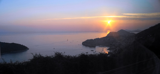
 10.  Sunset of Dubrovnik 
< 10. ドゥブロヴニクに沈む夕陽 >
The gulf that sunset reflects in is the old port.

This continues next time.


コトルに寄ってホテルに向かう途中でちょうどドゥブロヴニクの旧港に沈む夕陽に巡り合えました。
夕陽が反射している湾が旧港です。

次回に続きます。


20151111

社会と情報 61: 戦った報道 18


< 1. 昭和東北大凶作、1931~1932年 >

前回、日本政府の財政運営の困難さを見ました。
今回、国民の窮状を四人の発言から見ます。


四人の発言要約
三つの訴えと一つの打開策を紹介します。(文章は一部変更・割愛しています)


< 2. 幸徳秋水 >

訴えA:1904年3月、社会主義者幸徳秋水が書いた「平民新聞」の記事。文献1.

「多数の同胞は銃弾に曝され、その遺族は饑餓に泣き、商工は萎縮し、物価は高騰し、労働者は失業し、役人は給料を削られ、さらに軍債の応募を強いられ、貯蓄の献納を促され、その上多額の酷税となって、国民は血を涸らし、骨をえぐられる」


< 3. 渋谷定輔の代表的著作 >

訴えB:渋谷定輔が第一次世界大戦後(1917年)の農民生活をうたった。文献2.

「労働は20時間、後の4時間で寝食する、これがおれの生存だ、生活じゃない、・・、食物は麦入り飯とタクワンづけで、あとは腐れかかったさつま芋だ、・・」


< 4. 小沼正 >

訴えC:1932年2月、大蔵大臣井上を暗殺した22歳の小沼正の上申書。文献3.

「田植え時期なのに農家の倉庫に米一粒ない。肥料は? 出来る米をかたに高金利で肥料を借りるが、出来ると借金の利子と肥料と納税にとられ、残ったのは手に豆粒ぐらいだ。百姓が米を作って、米が食えないのだから日本も末だ。
 東京にいって、向島などの貧民窟を見た。・・長雨の後は一家餓鬼になる栄養不良、・・しかして哀れむべき、悲しむべき人々のために革命をすることに腹は決まった」


< 5. 満州事変の首謀者板垣征四郎(左)と石原莞爾 >

打開策D:1931年5月、参謀板垣征四郎は部隊長会同で発言した。文献4.

「満蒙問題の根本的解決は現状を打開し、国民の経済的生活を安定せしむる為の唯一の途であります。将来世界の大国に伍して民族永遠の発展を図り、帝国の使命を全うし得るか、又は小国に下落して独立性を失うかの分岐点に坐しているのであります」


説明
上記訴え三点を見ると、約30年の間、困窮と不満は減るどころか高まっている。

それに対して唐突ではあるが、打開策Dは国民の経済的生活を安定させる唯一の方法としている。
訴えと打開策との間には経済的に直接の関係が無いように見えるが、訴えCと打開策Dには別の繋がりがある。


< 6.血盟団事件の逮捕者、1932年 >

関東軍高級参謀の板垣はこの発言の4ヶ月後(9月)に満州事変を起こしている。
実は、訴えCの小沼(右翼)らは急進青年将校と結びついて満州事変蜂起に呼応し同年10月に国内で軍事クーデター(血盟団事件)を起こす予定だったが、失敗して再度次の年に決行した。

彼らは国内の経済問題解決に満州は必要だったと言っているのだが、軍部のより重要な意図は軍事上の戦略的価値であり、経済的には軍需産業を含む自給圏の確立だった。
この問題は後の機会に譲ります。


次回、国民の困窮の実態と背景を確認します。


文献
文献1:集英社版「日本の歴史18」、p209。
文献2:集英社版「日本の歴史19」、p250。
文献3:集英社版「日本の歴史20」、p56。
文献4:講談社版「日本の歴史23」、p117。


20151109

I visited Guilin 9: Historical town Daxuguzhen


桂林を訪れました 9: 大墟古鎮


< 1. The historical townscape >
< 1.大墟古鎮 >
The arched stone bond in the middle is a firewall.
途中にあるアーチ型の石積みは防火壁です。

Today, I introduce a historical town of Chinese style.
This town is about 20 km downstream of the central Guilin city and ever prospered in trade.
We visited in 9:20 - 10:20 on Thursday, September 17.
Finally, I introduce an interesting episode.

今日は、中国らしい古い街並みを紹介します。
ここは、桂林中心部より漓江を20km下った所にあり、かつて交易で栄えた町です。
9月17日(木曜日)の9:20~10:20に訪れました。
最後に、面白いエピソードを紹介します。


< 2. Map >
< 2. 地図 >
Upper map:  A yellow arrow is Daxuguzhen, and a red arrow indicates upstream side.
Central map:  An enlarged map. A red circle is our starting and ending point for sightseeing.
A yellow line is our tour route, and we shuttled on this route of about 400 m.
Lower fig.: A part of an illustrated handscroll that was made from the 10th to 12th century shows the prosperity of a capital city.
Probably, the Daxuguzhen had ever been prosperous with being full of ships, horses and merchants in this way.


上図:黄色矢印が大墟古鎮で、赤色矢印が上流を示し桂林中心部に至る。
青色矢印が漓江下りの開始点竹江です。
中央図: 大墟古鎮の拡大図。赤丸が観光出発・終了位置。
黄色線が徒歩ルートで、約400mの通りを往復した。
下図:「清明上河図」の一部。中国北宋(10~12世紀)の都開封の賑わいを描いた絵巻物。
おそらく大墟古鎮もかつてはこのように船と馬と商人で賑わっていたのだろう。


< 3. A prosperous street >
< 3. 通りの賑わい >

Actually, there only were Chinese tourists sparsely.
実は、中国系の観光客がまばらにいる程度でした。


< 4. Temple >
< 4.寺院 >
The Taoism temple had two pillars of dragon carved wonderfully.
An interesting thing is the second-floor porch on the right side.
Person hung a colander from here and exchanged the money and products between the ground in those days.

龍の彫り物が目を惹く道教の寺院です
扉は閉まっていたようです。
面白いのは右側のせり出した2階のベランダです。
当時、ここからざるを吊るして地上と商品とお金のやり取りをしていた。


< 5. Historical scenery
< 5. 他の遺構 >
Upper photo:  The arched bridge made of stones is since the 14th – 17th century.
Central photo:  A liquor shop. I smelled of the liquor when I looked in the inside.
Lower photo:  The house seems to be connected with a cultured person.

Many houses seem to be empty house or only old person living in it.

上写真: 明時代(14~17世紀)に石で作られたアーチ型の万寿橋です。
中央の写真: 酒屋。中を覗くと酒の匂いがしました。
下の写真: 文人と関係がありそうです。

多くの家は空き屋か、年寄りだけが住んでいるようです。


< 6.  Aspects of the backside of the street on the mountain side
< 6. 通り(写真1)の山側裏手の様子 >

Upper photo: Buildings of the 2nd - 4th floor are the backsides of the houses facing the street.
The frontage of each house is narrow, and several rooms of an earthen floor connect in the back.
Central photo:  Harvest by sun drying.

上の写真: 2階から4階の建物が、通りに面した家々の裏側です。
それぞれの家は間口が狭く、土間の部屋が何室も奥に続く。
中央の写真: 収穫物の天日干し。


< 7.  The backside of the street is Lijiang river >
< 7. 通りの裏は漓江 >
Upper photo:  A passage leads to the river from the street.
Central photo:  A view of downstream side.
Lower photo:  A view of upper stream side.

Many ships once had served shipping cargoes here.

上の写真: 通りから漓江に出る通路。
中央の写真: 下流を望む。右手対岸の山は島で、地元料理で有名だそうです。
下の写真: 上流を望む。渡しの船が行き来している。

かつてはここで多くの船が荷物の積み出しを行っていたのだろう。


About Daxuguzhen
This place already was a distributing center since the 3rd century B.C.
A waterway linked Pearl River and the Chang Jiang to the north and south, and an East-West land route crosses it here.
About 1100 years ago, this place became one of the 4th major markets of the Guangxi district.
In China, as the phrase “south ship and north horse” indicates, ship and horse met at this place.

Now, It is deserted, the state of preservation is not good, but there is good point that is not like a sightseeing spot.

大墟古鎮について
ここは紀元前3世紀から既に流通の拠点でした。
水路が南北に珠江と長江を結び、東西の陸路が交わるところでした。
約1100年前、北宋の頃から賑わい始め、明や清の時代には広西地区の四大市場の一つになっていました。
中国では古くから「南船北馬」と言われ、ここは船と馬が交わる町だった。

今は、寂れ保存状態が良くないが、観光地らしくない良さもある。


< 8.  A mansion 1 >
< 8. 屋敷 1 >
Episode
We looked in one house at the end.
In spite of a narrow frontage, the inside overflowed with many Chinese tourists in big merchant's house.
We entered inside, and were surprised by looking many rooms and courtyards and excellent decoration.
As entering furthermore, the mansion became expanse like a maze.

At that time, a young man called to us in fluent Japanese.
We were going to leave hastily, but he detained us.

エピソード
私達夫婦が、最後にある家を覗きました。
狭い間口にも関わらず、中は大きな商家で多くの中国人観光客で溢れていた。
中に入り部屋や中庭の数の多さ、立派な装飾に驚かされました。
どんどん中に入ると、迷路のように屋敷は広がり、私達だけになりました。

その時、若い男性が流暢な日本語で声を掛けて来ました。
私は急いで去ろうとしましたが、彼に引き留められました。


< 9.  A mansion 2 >
< 9. 屋敷 2 >

He started talking about he loves Japan and studied in the Japanese university.
His ancestor from Myanmar built this mansion.
Finally we were led to the back room to see family treasures.
However, we retired on the way because our waiting time would come.

The trip is really interesting.

This continues next time.


彼は日本が好きで、日本の大学に留学したことがあると喋り始めました。
そして、この屋敷はミャンマー出身の祖先が築いたものだそうです。
最後に、家宝を見せてあげようと奥に案内されました。
しかし、集合の時間が来たので、途中で退席しました。

実に、旅は面白い。

次回に続きます。


20151106

Went around Croatia and Slovenia 10: Korenica in an intermountain basin


< 1.  A morning of Korenica >
< 1. コレニカの朝 >

Today, I introduce Korenica that we stayed at a Hotel for Plitvice Lakes National Park.
I introduce a morning of Korenica, sceneries of the basin, and one episode.

今日は、プリトヴィッツェ湖国立公園への宿泊地コレニカを紹介します。
コレニカの朝と盆地の景色、そして一つのエピソードを紹介します。


< 2. The location of Korenica >
< 2. コレニカの位置 >

Upper map:  A black circle indicates port town Senj, a red circle does Korenica, and a blue circle Plitvice.
Lower map:  A green square indicates our hotel and a white arrow does a way to Plitvice.

上の地図: 黒丸は港町セニ、赤丸がコレニカ、青丸がプリトヴィッツェを示す。
下の地図: 緑の四角が宿泊ホテル、白矢印がプリトヴィッツェへの道を示す。


< 3.  Our hotel is Macola in Korenica >
< 3. コレニカのホテルMacola >

Korenica

The distance from here to Plitvice is 18 km, there is not a town on the way.
This place is a calm basin.
There is the hotel in the center of the town, and it faced a main street.
The hotel is medium scale and I was satisfied with the service.
Members of the tour were pleased because there was a big convenience in the underground of the hotel.
It is one of a chain store, has a lot of kinds of goods, and we can use cards.
After returning home, I knew it and wondered that the receipt was expressed in local currency of Bosnia and Herzegovina neighboring country.
The currency in Croatia should have been Euro or Kuna.
This relates to a later episode.

コレニカの町
ここからプリトヴィッツェまで18kmで、途中に町はありません。
ここは盆地で、のどかな所です。
ホテルは町の中央にあり、通りに面しています。
ホテルは中程度の大きさで特に気になるところはありませんでした。
皆が喜んだのは地下に規模の大きいコンビニがあったことです。
ここはチェーン店で品揃えも多く、カードも使えます。
帰国後知ったのですが、レシートの金額表示が隣国ボスニア・ヘルツェゴビナの通貨表示で、不思議に思いました。
通貨はスロベニアでユーロ、クロアチアでユーロとクーナのはずでした。
このことは後のエピソードと関わりがあります。

Strolling in the morning
We strolled around the hotel at about the sunrise from 6:20 to 6:50 on September 1.
The town was silent and a little chilly.

朝の散策
9月1日、6:20~6:50、日の出間近に散策しました。
町はひんやりと静まりかえっていました。


< 4. The stroll around the hotel 1 >
< 4.朝、ホテル周辺を散策 1 >
Upper photo:  I look at the hotel side (a white building in the back) from the back of the hotel.
Central photo:  The morning slowly was coming silently.
Lower photo:  It is like a farmhouse.

上の写真: ホテルのすぐ裏からホテル側(奥の白い建物)を見ています。
中央の写真: 静寂の中、ゆっくりと朝が明けていきます。
下の写真: 農家のようです。


< 5. The stroll around the hotel 2  >
< 5.朝、ホテル周辺を散策 2 >
Upper photo:  It is like a small hotel and this place is convenient to go to the national park.
Central photo:  A spire at the back is church.
Lower photo:  We completed a stroll around the hotel.

上の写真: プチホテルのようです。ここは国立公園に行くには便利な所です。
中央の写真: 奥に見えるのがキリスト教会の尖塔です。
下の写真: 一周して中央の通りに出て来ました。

Episode

エピソード


< 6.  Views of car window while we went to Korenica area from Plitvice 1 >
< 6.プリトヴィッツェからコレニカに向かう車窓から 1 >

We had lunch on the way, and passed through these places from 11:40 to 13:30.
Bucolic scenery with a lot of green continues.
However, I saw some deserted houses, and houses with bullet holes on the way to the hotel on the day before.

途中昼食をとり、11:40~13:30、ここを通過しました。
緑が多い牧歌的な景色が続きます。
しかし、前日、ホテルまでの道のりで廃屋や銃弾の跡がある家屋をいくつか見ました。


< 7.  Views of car window while we went to Korenica area from Plitvice 2 >
< 7.プリトヴィッツェからコレニカに向かう車窓から 2 >

There was not a village in the neighborhood, but there was a big graveyard for some reason.
These many gravestones were Catholic type, but although the number is still small, there were gravestones of Greek Orthodox and Islam among these, too.
Close by was a open space where two tanks facing each other were put.

周囲に村は見えないのですが、なぜか大きな墓地がありました。
墓石はカソリック系が多いのですが、その中に、数は少ないが正教会系やイスラム系の墓石もありました。
すぐ近くに、二台の戦車が対向して置かれている広場がありました。


< 8.  At Plitvice Lakes National Park >
< 8.プリトヴィッツェ湖国立公園にて >

The center was a guide of this park and was very openhearted woman favoring Japan.

She was born here, but this area became a site of a hard-fought battle by Yugoslavia civil war.
She and her mother got separated from her father and evacuated in the distance for several years.
Before long, she reunited with the father, returned back to favorite hometown, and works as guide of the parks now.

中央が今回の公園のガイドで、日本贔屓の非常に気さくな女性でした。

彼女はこの地で生まれたが、ここ一帯はユーゴ内戦で激戦地となりました。
彼女とお母さんはお父さんとはぐれて、数年間遠くに避難しました。
やがてお父さんと巡り会え、今は好きなふるさに戻り、公園のガイドとして働いています。

Afterword

A fountainhead of this misfortune was to have instituted the Military Frontier of the 16th century, and the ethnic antagonism began because many Serbians lived in this area of Croatia.
Before the civil war, Serbians and Muslims that are the majority of neighboring country Bosnia and Herzegovina lived across the border from here.
This thing seems to relate the gravestone type of various religious groups and indication of the receipt.

In this trip, I thought that a race and the border is something.

This continues next time.

あとがき
彼女に降りかかった災厄の淵源は16世紀の軍政国境の設定にあり、クロアチアのこの地に多くのセルビア人が住んでいたことで民族対立が噴出したのです。
内戦前、ここから国境をまたぐ地域には隣国ボスニア・ヘルツェゴビナの多数派であるセルビア人とムスリム人が多く住んでいました。
そのことが異なる宗派の墓石やコンビニのレシート表示につながったのかもしれません。

国境とは何か、民族とは何かを考えさせられる旅となりました。

次回に続きます。