20160201

Went around Croatia and Slovenia 24 : Deeply scarred Town Mostar 3

クロアチア・スロベニアを巡って 24: 傷痕の町モスタル 3


< 1.  I look at the old city from a riverside restaurant of Neretva >
< 1.ネレトヴァ川沿いのレストランから旧市街を眺めた >

A sequel to the introduction of Mostar
モスタル紹介の続きです


< 2.  Views of Strai Most (old bridge) from both sides >
< 2. 両側から見た石橋 >

Upper photo:  A view from the yard of the mosque.
A large cross stands on the top of the mountain.
Lower photo:  A view from the riverside on the downstream side.
A man just is going to jump into the river from the top of the bridge.
Each time he gets money, he jumps.
There is the jumping event annually here.

上の写真: モスクの庭からの眺め。
山頂に大きな十字架が立っている。

下の写真: 下流側の川辺から。
橋の上の中央から男性が今にも飛び込もうとしている。
彼はお金を貰っては飛び込んでいる。
年一度、ここで飛び込みの大会があります。


< 3.  Visit to “Turkish house” in the old city >
< 3. 旧市街の「トルコの家」を訪ねて >

Upper photo:  The minaret that we climbed can be seen.
Central photo:  When we were badly bunkered as we don’t find “Turkish house” at a map of a signboard, somebody called to us from behind and taught the pathway to it.
This kind man is the left side on the photo.
I think the map indicated not “Turkish house” but “Ottoman house”.

Lower photo:  “Turkish house”
When we arrived on it, we looked at only the entrance and had to return because our free time just was over.

上の写真: 私が登ったモスクのミナレットが見える。
中央の写真: 私達は看板の地図に「トルコの家」が見つからなくて困っていました。
すると後ろから声を掛けてくれる人がいて、道を教えてくれた。
その人が、写真左側の人でした。
看板には「トルコの家」ではなく「オットマン・ハウス」と表記されていたように思う。

下の写真: トルコの家。
辿り着いた時には戻る時間になっていて入口を覗くだけで引き返した。

We left Mostar and went to the next stage.

モスタルを出て、次の宿泊地に向かう。


< 4.  We left Mostar >
< 4. モスタルと別れる >

Lower photo:  I looked back toward Mostar located in the valley from the downstream side of Neretva.

下の写真: ネレトヴァ川の下流側から谷間にあるモスタルを振り返る。


< 5.  We parted from the Neretva >
< 5. ネレトヴァ川とも別れる >

We part from the Neretva at here, passed through the high plateau and went to the Adriatic Sea.
ここでネレトヴァ川とも別れ、高原を抜けてアドリア海岸へと向かう。


< 6. We passed through the high plateau >
< 6. 高原を抜けて >

This high plateau was a dry zone as a whole, but there also were lush green places.

On the next time, I introduce another scenery of Mostar, and Bosnian War.

高原は乾燥地帯だが、緑豊かな所もあった。

次回は、モスタルの新市街とボスニア・ヘルツェゴビナ紛争を紹介します。


20160127

桂林を訪れました 15: 最後に


< 1. 少数民族雑伎ショー >

今日で、この旅行記を終えます。
書き残したことや雑感を記します。


< 2. これまでの記事の巻頭写真 1 >

この桂林旅行は2015年9月初旬に3泊4日で訪れたものです。
予想通りに天候に恵まれ、漓江下りと龍背棚田の景色を堪能しました。
また大墟古鎮やヤオ族の村の見学は短い時間ではあったが楽しめました。


< 3. これまでの記事の巻頭写真 2 >

少し残念なことは、ヤオ族の風習や宗教などに触れる時間がなかったことです。
それでも得るものはありました。
しかし、思わぬ拾いものが別でありました。
それは下の写真です。


< 4. 花山岩画 >

これは中国が2015年に世界遺産登録を申請したものです。
私達が穿山岩の鍾乳洞を見学していると偶然、この展示ポスターを見つけました。
これはこの広西省にあって、約2千年前にチワン族の祖先によって岩に描かれた絵でした。
この人物像のデザインは他の大陸では1万年前に遡ることがあります。
中国にはこの手の古い岩絵が少ないので、何だか嬉しくなりました。


< 5. 桂林 1 >

中国の奥地にあって、開発が遅れていると思っていたのですが、そうではなかった。
田園地帯に行っても建設中の家屋や、郊外にも高層マンションが林立していました。
郊外に産業団地があるのですが、研究所や公害を出さない事業体が誘致されていた。
町中を走っている車やバイクはほとんど電動車だそうです、公害防止の為に。
都市部を少し離れるとそこら中、砂埃をあげて道路工事やビルの建設中でした。


< 6. 桂林 2 >

私達夫婦は毎朝晩、町中を歩き回りましたが、危険や不安を感じることはなかった。
二軒の本屋の店員も、夜、道に迷って宝石店の店員に道を尋ねても、皆丁寧に対応してくれた。
残念ながら言葉は通じなかったが。

少数民族の雑伎ショーには私の期待していた少数民族の風習や暮らしを紹介するものはなかった。
それでも巻頭写真にあるような男女の掛け合いの歌は、山岳民族に最近まで続いていた「歌垣」を思わせるものがあった。
この歌による求婚方式は、日本では奈良時代で消えてしまった。

ここでは観光業に力を入れることにより、少数民族は肩身の狭い思いをすることなく暮らしているように思えた。
ただ観光化が進みすぎて、保存すべきものが失われているのが残念です。


最後に
私は中国の訪問が7回目ですが、20年ほど前に比べて中国は力強く発展を続け、人々の振る舞いも変わってきているように思う。
経済格差、古いものと現代的なもの、汚いものと洗練されたもの、ごった煮の状況は変わらないが。

やっと念願の奥地の桂林を訪問し、満足して去ることが出来ました。
皆さん、お読み頂きありがとうございました。


20160125

Went around Croatia and Slovenia 23 : Deeply scarred Town Mostar 2

クロアチア・スロベニアを巡って 23: 傷痕の町モスタル 2          


< 1.  Old Bridge made by stones >
< 1.石橋「スタリ・モスト」 >

Today, we go for a walk in the old town of Mostar.
This old town is a town of Muslims.

今日は、モスタルの旧市街を歩きます。
旧市街はイスラム教徒の町です。          


< 2.  Go to the old town >
< 2. 旧市街に向かう >

Upper photo:  We just go out of the parking lot.
We left it at 11 A.M.

Central and lower Photos:  The street lined with souvenir shops.

上の写真: 駐車場から出るところです。
私達は11時に駐車場を出発しました。

中央と下の写真: 通りには土産物屋が並ぶ。


< 3.  Go to the Old bridge >
< 3.石橋に向かう >

Upper photo:  When I looked back, there were many traces of bullet on the store’s wall.
Lower photo:  The gate of the Old bridge.
You can see the top surface of the bridge behind the gate.

This bridge was restored in 2004 after its old bridge was destroyed by a civil war in 1993.
This was reproduced in its original condition made in the 16th century.

上の写真: 振り返ると店舗の壁に銃弾の跡がありました。
下の写真: 石橋の門です。
門の向こうに階段状の橋の上面が見える。

この石橋は1993年の内戦で破壊された後、2004年に復元されたものです。
これは16世紀に造られた当時のままに再現された。


< 4.  Views from the top of the bridge >
< 4. 石橋の上から >

Upper photo:  Downstream side of Neretva river.
Central photo:  Old bazaar we are going to go from now is seen. 

Lower photo:  Upstream side of it.
The minaret of a mosque we are going to climb after this is seen in the center.

上の写真: ネレトヴァ川の下流側。
中央の写真: これから行く旧市街のオールド・バザールが見える。
下の写真: 上流側。
これから登るモスクのミナレットが中央に見える。


< 5.  The Old bazaar >
< 5.オールド・バザール >

Mostar had prospered in trade, because it was located on a caravan route that linked the Adriatic Sea and the inland.
Mostar led to the Dubrovnik and Kotor that I already introduced.
The Old bazaar was a craftsman town that many copper craftsmen, tanners and tailors lived in.
There was an oriental atmosphere here.

モスタルは内陸とアドリア海を結ぶキャラバン・ルートにあり、交易で栄えて来た。
既に紹介したドゥブロブニクやコトルに通じていた。
このオールド・バザールはかつて銅職人やなめし職人、仕立屋などが住んでいた職人街です。
ここにはオリエンタルな雰囲気が漂っていた。


< 6.  Arrived at the mosque  >
< 6. モスクに来ました  >

Upper photo:  We went into the yard of the mosque.
The central hexagonal building is intended for cleaning up hands and feet.
                                                                                                                    
Lower photo:  In front of the mosque.
This Koski Mehmed pasa Mosque made in the 16th century is famous for a beautiful prospect.

上の写真: モスクの庭内に入って来た。
中央の六角形の建物は手足を洗い清めるところです。

下の写真: いよいよモスクに入ります。
これは16世紀に建てられたコスキ・メフメドパシャ・モスクで、眺めが良いので有名です。


< 7. Inside the mosque >
< 7. モスクの中 >

Upper photo:  there are a hollow of wall “ mihrab”, and a step-like preacher's pew “ mimbar”.
Central photo:  The ceiling.
Lower photo:  The stairs inside the minaret.

上の写真: メッカを示す壁の窪み(ミフラーブ)と階段状の説教壇(ミンバル)が見える。
中央の写真: 天井。
下の写真: ミナレットの階段。


< 8.  A view from the top of the minaret >
< 8. ミナレットから見た石橋 >

It is a view of downstream side.
下流側を見ている。


< 9.  Views from the top of the minaret
< 9.ミナレットからの眺め >

Upper photo:  It is a view of upper streamside and the north side.
A spire on the left is a church near our parking lot.

Lower photo:  I look at the old town of the east side.

This continues next time.


上の写真: 上流側で、北側です。
左に見える尖塔は私達の駐車場横にある教会です。

下の写真: 東側の旧市街を見ています。


次回に続きます。


20160121

桂林を訪れました 14: 龍脊棚田 4


今日で、この村の紹介を終わります。
非常に短い時間だったが、心地良い訪問だった。


< 2. さらに上の村を目指して >
中央の写真: 軒先に掛かっている黄色いものはトウモロコシのようです。

赤い旗が見える一番高い村を目指して上ろうとしたが、私達には限界だった。
足は震え、心臓は躍っていた。
ここで折り返すことになったが、下りの道のなんと急なこと。
村人が日々、ここを行き来していることに驚かされる。


< 3. 途中で出会った自然 >


< 4. 村を振り返る >

上の写真: 私達は右に見えるの集落の下から半分を越えたに過ぎない。
この下にも集落があり、実に上下に延びる密集した大きな村でした。
日本の急斜面の山村はおそらく広く分散しているはずです。
ここにも中国が氏族や部族の繋がりを大事にしている様子が出ているようです。

下の写真: 帰る頃には、晴れ間が少し見えて来ました。


< 5. 中国ドラマ「傾城の雪」 >

上の写真: 皇宮で行われた刺繍の大会。
下の写真: 雲南の婚礼衣装。

私達は旅行に行く前、中国歴史ドラマ「傾城の雪」にはまっていました。
このドラマは明時代の刺繍の名家が舞台で、蘇州の皇宮と雲南の村の文化を描いていた。


< 6. ヤオ族の婚礼 http://sakuraproject.org/mien.html >

今回の旅行では民族衣装を見ることは出来なかったが、中国南部の少数民族の衣装には共通点があるように思える。
上記の写真と中国ドラマの婚礼衣装には、銀の装飾品、豪華な刺繍、黒と赤が基調になっており、服の作りも似ている。
以前、台湾を旅行した時に見た少数民族の衣装とも似ている。

私達日本の国生み神話(淡路島誕生)や里見八犬伝のルーツもこの中国南部の少数民族にある。
1万年を遡る稲作誕生、やがて漢民族の優勢によって南下した人々、その文化が台湾や日本に伝来した。
この遥かなる繋がりを感じることが出来た旅でした。


次回に続きます。


20160119

Went around Croatia and Slovenia 22: Deeply scarred Town Mostar


クロアチア・スロベニアを巡って 22: 傷痕の町モスタル 1


< 1.  Župa Svetog Petra i Pavla is a church in Mostar
< 1.モスタルの教会、Župa Svetog Petra i Pavla

Today, we go to the intermountain town in Bosnia and Herzegovina.
I introduce the scenery between coastal town Neum and the Mostar.

今日は、ボスニア・ヘルツェゴビナの山間の町に向かいます。
海沿いの町ネウムからモスタルまでの景観を紹介します。


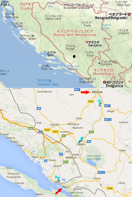
< 2.  Root maps >
< 2.地図 >

Upper map:  It shows Bosnia and Herzegovina.
A black point is the Mostar.

Lower map:  It shows the way to the Mostar from the Neum that we stayed in.
Red arrows show the two towns, and blue arrow shows the root.
The distance between the Mostar and the Neum is about 60 km.
We left at 9 A.M. on September 3, 2015, and arrived at 11 A.M.
It took much time, because we went through two checkpoints on the border.

上の地図:  ボスニア・ヘルツェゴビナを示す。
黒丸がモスタルです。

下の地図: ホテルのあるネウムからモスタルへの道を示す。
赤矢印が二つの町を示し、青矢印はそのルートを示す。
ネウムからモスタルまでは約60km。
2015年9月3日、9時に出発し11時に到着した。
時間がかかったのは、2箇所の国境検問所を通った為です。

About Mostar

1992-1995, Bosnia and Herzegovina was involved into Yugoslav Wars.
At this time, we have known the capital Sarajevo became the battlefield, and similar tragedy occurred in the Mostar, too.
Race of this nation consists of the most Muslims, subsequently a Croatian of the Christian, and a Serbian of the Greek Orthodox Church.
And this nation has a border with Croatia and Serbia.
By this, this Muslims suffered damage by ethnic cleansing by a Serbian at the time of Yugoslavia's collapse.

モスタルについて
1992~1995年、ボスニア・ヘルツェゴビナはユーゴ紛争に巻き込まれました。
この時、首都サラエボが戦場になったことはよく報道されたが、モスタルでも同様の悲劇が起こりました。
この国の民族は、イスラム教徒が一番多く、次いでキリスト教徒のクロアチア人、正教会のセルビア人で構成されている。
かつ、この国はクロアチアとセルビアと国境を接している。
このことにより、ユーゴスラビア崩壊時にイスラム教徒はセルビア人から民族浄化の被害を受けた。


< 3.  Sceneries between the Neum and downstream of Neretva >
< 3. ネウムからネレトヴァ川の下流まで >

Upper photo:  People had been enjoying a marine vacation.
Central photo:  As going through a mountain pass, I saw a monastery (?) on the hill.
Lower photo:  The plains that spread out downstream of Neretva river.

上の写真:  リゾートを楽しむ人々の姿が見える。
中央の写真: 峠を通過中、丘の上に修道院(?)が見えた。
下の写真:  ネレトヴァ川の河口に広がる平野部。


< 4.  We were coming down to the plains >
< 4. 平野部に降りていく >

There are lots of dry mountains in this area, but this place is filled with green.
乾燥した山間地が多い中にあって、ここは緑に溢れていた。


< 5.  Towns along the Neretva >
< 5. ネレトヴァ川沿いの街並み >

Upper photo:  I saw a mosque for the first time in this trip.
Graveyard of Islam is seen on the left side.

Central photo:  Neretva.
Lower photo:  Soccer seems popular.


上の写真: 今回の旅行で初めてモスクを見た。
左側に見えるのがイスラムの墓です。

中央の写真: ネレトヴァ川。
下の写真: サッカーが盛んなようです。


< 6.  We go into the mountain valley >
< 6. いよいよ川沿いに山間地へと上って行く >

People are growing grapes as hard as possible at the dry mountain area.

乾燥している山間地でも、人々はぶどうなどを精一杯栽培している。


< 7.  Near Mostar >
< 7. モスタルに近づいた >

Central photo:  Graveyard of Christianity system.
Lower photo:  We can look at innumerable traces of big bullet on the outer wall of the apartment.

This continues next time.

中央の写真: キリスト教系の墓地です。
下の写真:  アパートの外壁に大きな銃弾の跡が無数に見える。

次回に続きます。


20160115

桂林を訪れました 13: 龍脊棚田 3


*1

今日は、ヤオ族の村を歩きます。


< 2. 村を行く >

私たちは民家を抜けて、もっと上にある村を目指して歩き始めた。
ここに掲載している写真は12:24から12:39に撮影したものです。


< 3. 村の門 >

多くの民家が集合しているが、上下で村が幾つかに分かれている。
これは、これから登っていく村の門で、風水にかなっているそうです。
この門は清時代の1883年に、繁栄と魔除を願って村人300人が運んで来て造ったものです。
扉の左の武将の胸に陰陽を表す太極図が彫られている。
私は、念願の道教との関連物をやっと見つけることが出来た。


<4.橋の風情 >

村人の写真は、ガイドさんが相手に了解をとってから撮影しています。
昼の休憩で、村人が談笑しているのでしょうか。
近くのトン族は橋を共有の建物として壮麗に作るが、ここでも屋根付の憩いの場として使っていた。


< 5. 人々 >

この写真以外にも見かけたのですが、昼でも多くの女性は共同で働いていた。
頭のタオルはヤオ族の習俗のようです。
ここでも高齢化が進んでいる。


< 6. 暮らし >

石の門扉のあった村の最上部に来ました。
上の写真: 村の中央を流れる川の上流に共同の洗い場が見えます。
その川の下流では数羽の鶏が、村人の流した残飯などをついばんでいる。

下の写真: 洗い場です。
ちょうど二人の女性が洗濯をしている。
右の屋根は杵つき小屋です。


< 7. 村の利器 >
上の写真: 洗い場。
右側に竜の形をした流水口が見える。

左下の写真: 杵つき小屋。
杵の後ろの容器に流水が溜まると杵が跳ね上がり上下運動を繰り返す。
昔はここで穀物を粉砕していたが、今は使っていない。
右下の写真: 民家の床下の水車。


次回は、ヤオ族の村の最後の紹介です。


20160112

Glistening white Himeji Castle 2


白く輝く美しい姫路城 2


*

Today, I introduce the latter half of the Himeji Castle sightseeing.
今日は、姫路城の紹介の後半です。


< 2.  Views from the castle tower top floor >
< 2. 天守閣最上階からの眺め >

Upper photo:  The castle walls extending to the west are seen.
Central photo:  We can see the open space that was once a building ” Sannomaru”, and the moat to the left side.
Lower photo:  “Shachihoko” is placed on the end of the tile roof in the south side.
This statue is made from the head of a tiger and the body of a fish, it stands on its head, and it becomes a charm against evil.

上の写真: 西側に延びている曲輪(城壁)が見える。
中央の写真: 南側の三の丸広場、左側に堀が見える。
下の写真: “しゃちほこ”が南側にせり出した屋根に載っている。
この“しゃちほこ”は頭が虎で体が魚で逆立ちしており、魔除けになっている。


< 3.  Inside the castle tower >
< 3. 天守閣内部 >

Upper photo:  The window side of the top floor.
Central photo:  The small shrine is seen in the center of the top floor.
Lower photo:  The first floor of the underground cannot get sunshine from windows.
Two large pillars are seen.

上の写真: 最上階の窓側。
中央の写真: 最上階の中央に神社の祠が見える。
下の写真: 最下層、窓の光がささない地下一階。
二本の大柱が見える。 


< 4.  Dignified appearance of the castle tower >
< 4. 天守閣の威容 >

Upper photo:  This castle tower consists of a main tower, and three small towers located around it.
One of those is seen to the left.

Central photo:  An expansion of the main tower.
Lower photo:  We can see the moat of the south side, and the main gate to the right side.

上の写真: 天守閣は大天守とその周りの三つの小天守からなります。
左にその内の一つが見えます。

中央の写真: 大天守の拡大です。
下の写真: 城の南側の堀と右に大手門が見えます。


< 5.  The castle tower from “ Ninomaru” >
< 5.二の丸付近からの天守閣 >

About the Himeji Castle
The history began from a fort of Muromachi era in the 14th century, and military strategist Kanbei Kuroda built the castle here in the last of the age of provincial wars.
After that, lords of the castle changed on several occasions, but the present castle tower leaves a figure of the Edo era.
The castle’ buildings were built as swirling around the main building “ Honmaru” being near the castle tower on a small hill of big plain.
A distance between the east and the west of the moat surrounding the castle is approximately 500m.

Afterword
It was very fine.
The admission fee of New Year's Day was free, there were not the traffic jam of the road, so we could enjoy.
Our castle sightseeing was two hours from 9:00.
I am going to visit again when the cherry tree blooms.


姫路城について
その歴史は14世紀、室町時代の砦に始まり、戦国時代末期に軍師黒田官兵衛がここを居城とした。
その後、城主は代わっていたが、今の天守閣は江戸時代の姿をそのままに残している。
この城は平野部の小高い丘の上に本丸(天守閣の近くにある)を中心に渦が巻くように作られた城です。
周囲を巡っている堀の東側と西側の距離は約500mです。

あとがき
非常に天気が良かった。
元旦は入場料が無料で、道路の渋滞もなく、ゆっくり楽しめました。
城内を見学したのは9時から2時間です。
桜の咲く季節にはまた来たいと思います。