20141226

Traveling to Spain and Portugal 32: Segovia is known for aqueduct, Spain, October 23


スペインとポルトガルを巡る旅 32: 水道橋で知られたセゴビア、スペイン、10月23日


Aqueduct. Photographing at 8:00 

< 1.  Aqueduct. Photographing at 8:00 >
< 1. 水道橋、8:00撮影 >

Today, I introduce the last sightseeing area, Segovia famous for aqueduct and the castle of Snow White.
今日は、最後の観光地、水道橋と白雪姫の城で有名なセゴビアを紹介します。


< 2.  We had arrived to Segovia on the previous day 
< 2. 前日、セゴビアに到着 >
Upper photo:  We go in Segovia after 10 minutes. Photographing at 17:55.
Lower photo:  A view of the old city from our hotel. Photographing at 18:35.
上の写真: 後10分ほどでセゴビアに入る。17:55撮影。
下の写真: ホテルから旧市街を臨む。18:35撮影。


Map: A red line shows our sightseeing route.

< 3.  Map: A red line shows our sightseeing route.
< 3. 地図:赤線が観光ルート >

The upper part of the map is the north.
The number of the map shows the photo number and the photography spot, and is in order of the photography.
We started from a yellow circle at 7:55, went uphill and traversed the old city by foot, went downhill, and then arrived at blue circle, and we finished the sightseeing at 9:40.  
At this time, there was not sightseeing of admission, too. 

地図上方が北。
地図中の番号は、写真番号と撮影場所を示し、撮影順序通りです。
7:55に黄丸印を出発し、徒歩で上って旧市街を縦断し、また下って青丸印へ9:40に到着し観光を終えた。
今回も入場観光はなし。

About Segovia

From time immemorial, this hill was being ruled by Celt, Roman, the Goths and Muslim.
After Christian had forced Muslim out of this area, and this hill became a castle city of Castile in the 13th century.
This area was a route of transhumance, and the woolen industry developed, therefore this area soon entered the golden age.
By a law for the protection of sheepherder of this time, Spanish people were not able to own cultivated land for centuries.
In the 16th century, Segovia was destroyed thoroughly by the revolt that Segovia participated for obtaining the autonomy of the city together with 15 cities.
However, they accomplished the rebuilding.

This fortress city at 1000 m above sea level is on high hill whose surrounding was hollowed by two rivers, and is 90 m high from the rivers to the top.
Therefore, the aqueduct was necessary to supply it with water from the upper reaches.

セゴビアについて
ここは古くはケルト人、ついでローマ人、ゴート人、やがてイスラム教徒が支配した。
キリスト教徒がイスラム教徒をこの地域から追い出すと、13世紀、ここがカスティーリャ王国の王都となった。
ここは移牧のルートにあたり、毛織物産業が発展し最盛期を迎えることになる。
この時の羊飼い擁護の法律により、何世紀もの間、スペインは耕作地を持つことが出来なかった。
16世紀、セゴビアも参加した自治都市権獲得(15都市が参加)の反乱で、ここは徹底的に破壊された。
しかし、彼らは再建を成し遂げた。

この城砦都市は、二つの川で抉られた標高1000の高台(川から90mの差)にある。
したがって上流から給水するために水道橋が必要だった。


aqueduct and plaza 

< 4.  aqueduct and plaza >
< 4. 水道橋と広場 >
1:  plaza having an aqueduct.
2:  The highest place of the aqueduct is 29m high in this plaza.
3:  The aqueduct connects with the top of the castle wall surrounding the old city.
4:  Once, the aqueduct had supplied water from distant mountain of 15 km behind.

The aqueduct was made by Roman in about the 1st century B.C., and was destroyed by Muslim in the 11th century.
We are seeing the thing reconstructed in the 15th century.

1: 水道橋のある広場。
2: 水道橋の一番高い所はこの広場で29mある。
3: 水道橋は旧市街を囲む城壁に繋がっている。
4: かつて水道橋は遠方の山手、15km先から水を供給していた。

この水道橋は紀元前1世紀頃、ローマ人によって造られ、11世紀にイスラム教徒によって破壊された。
私達は15世紀に再建されたものを見ている。


< 5.  A street proceeding to Cathedral >
< 5. カテドラルに向かう通り >
6:  We leave the plaza and went up about 20 meters high to Plaza Mayor.
7:  As I look down at the south side, I can see an Iglesia (church) of Romanesque style in the twelfth century.
8,9:   The design of the outer wall is beautiful. Influence of Islam is seen.

6: 広場を後にして、マヨール広場まで20m程上っていく。
7: 南側を見下ろすと、12世紀のロマネスク様式の教会が見える。
8、9: 外壁の模様が美しい。イスラムの影響が見られる。


Iglesia de San Martin and street

< 6.  Iglesia de San Martin and street >
< 6. サン・マルティン教会と通り >
10:  Iglesia de San Martin of Romanesque style.
12:  The bell tower of cathedral came in view.

10: ロマネスク様式のサン・マルティン教会。
12: カテドラルの鐘楼が見えてきた。


 Cathedral 

< 7. Cathedral >
< 7. カテドラル >
This is Spanish last build of Gothic style, began to be built in the 16th century and completed 240 years later.
It is called "A lady of cathedral" from the elegant form.

16世紀に建設が始まり、240年後に完成したスペイン最後のゴシック大聖堂。
その優美な姿から「カテドラルの貴婦人」と呼ばれる。


Plaza Mayor and a street market 

< 8.  Plaza Mayor and a street market >
< 8. マヨール広場と露天市 >

The market was opening in Plaza Mayor in front of the cathedral.
It had aimed to not tourist but citizens.
I looked for books in a secondhand bookstore, but there unfortunately was not the thing that I wanted.

カテドラルの前のマヨール広場で市が開かれていた。
観光客目当てではなく市民向けの市でした。
私は古本屋を物色したが、欲しいものが無く残念でした。


< 9.  Alcazar >
< 9. アルカサル >
The castle became the model of "the castle of Snow White" of Disney.
It was made in the eleventh century on fortress remains of the Roman era, and became the form like the present in the 15th century, but it was restored after a big fire.
This castle was built on the cliff of 60 m in height that was sandwiched by two rivers.

ディズニーの「白雪姫の城」のモデルになった。
城はローマ時代の要塞跡に11世紀に造られ、15世紀に現在のような形となったが、大火後修復された。
この城は、二つの川に挟まれた高さ60mの崖の上に建っている。


Iglesia and Alcazar

< 10.  Iglesia and Alcazar >
< 10. 教会とアルカサル >
18:  A church of Romanesque style in the twelfth century.
21:  Iglesia de la Vera Cruz of an unusual dodecagon.
When I looked down, the small church was seen in the wasteland of the north side.
The Knights Templars (defend Jerusalem) built it in the 13th century, and the crucifixion cross of Christ is preserved.

22:  we went down steep stairs along the cliff from the Alcazar, and we photographed from an open space.

18: 12世紀のロマネスク様式の教会。
21: 珍しい12角形のラ・ベラ・クルス教会。
見下ろすと、北側の荒野に小さな教会が見えた。
これはテンプル騎士団(エルサレム防衛)が13世紀に建てたもので、キリストが磔にされた十字架が保存されている。

22: アルカサルから崖に沿って急な階段を降りた広場から撮影した。


 I say good-bye to Segovia and Iberian, “Sayounara!  Adios!  Adeus!”

< 11.  I say good-bye to Segovia and Iberian, “Sayounara!  Adios!  Adeus!”
< 11. セゴビアとイベリアに別れを告げて、さようなら! アディオス! >
                 
I finish the last sightseeing and, in the afternoon of this day, return home from an airport of Madrid.
I am blessed with beautiful weather in spite of rainy season and am parting with the sun and the town of the Middle Ages now.

From the next time, I write down Barcelona and Antoni GaudiSagrada Familia, the Prado Museum of Art Madrid,  and shopping information.

最後の観光を終え、この日の午後、マドリッドの空港から帰国する。
雨期にも関わらず快晴に恵まれ、これで太陽と中世の都ともお別れです。

次回から、バルセロナやプラド美術館、ガウディ、ショッピング情報などを記します。


20141225

Traveling to Spain and Portugal 31: Avila city of a castle wall, Spain, October 22


スペインとポルトガルを巡る旅 31: 城壁の町アビラ、スペイン、10月22日


A sightseeing place and Avila of fortress

< 1. A sightseeing place and Avila of fortress >
< 1.展望台と城砦都市アビラ >

Today, I introduce Avila famous for rigid castle wall.
今日は、堅牢な城壁で有名なアビラを紹介します。


Avila came into view 

< 2.  Avila came into view >
< 2.アビラが見えてきた >
Upper photo:  Our bus had run through the plateau from Salamanca, and our bus began to climb additionally.
Central photo:  A tower of Cathedral in Avila came into view on the right end.
Lower photo:  A full view of the castle wall of Avila.

About Avila

This was a city that was made by the Roman Empire in ancient times, and is the capital of a province now.
It is really cold in winter because that it is on higher plateau of 1131 m above sea level.
It is located in about 100 km from Salamanca in direct distance, and in about 90 km from Madrid in direct distance by traversing mountain range with south and east.
This castle wall is in a good state of preservation, and became the world heritage.


上の写真: サラマンカから高原地帯を走って来たが、更にバスは上り始めた。
中央の写真: 右端にアビラの大聖堂の塔が見えてきた。
下の写真: アビラの城壁の全景。

アビラについて
ここは、古くはローマ帝国の植民都市で、現在、アビラ県の県都です。
ここは海抜1131mの高地にある為、冬は厳しい。
ここはサラマンカから直線距離で約100km、東南にある山脈を越えて直線距離で約90km行くとマドリッドに至る。
この城壁は保存状態が良く、世界遺産となっている。


the old city and the castle wall 

< 3.  the old city and the castle wall >
< 3. 旧市街と城壁 >
Upper photo:  A cathedral is seen in the center of inside of the castle wall.
Central photo:  The castle wall began to be built when people recaptured this town from Muslim in the 11th century, and was completed after 9 years.
The castle wall has 2.5km in total length, 12m in height, width approximately 3m, 88 towers and parapet wall.

上の写真: 城壁内の中央にカテドラルが見える。
中央の写真: この城壁は、イスラム教徒から町を奪還した11世紀末から9年をかけて建設された。
城壁は全長2.5km、高さ12m、巾約3m、88の塔と胸壁を持つ。


Gate de San Vicente

< 4.  Gate de San Vicente >
< 4. サン・ビセンテ門 >
It is a representative gate as appearing heavy.
Seeing the structure, I understood they had aimed at inexpugnableness for providing for the attack of the Muslim.

Lower two photos:  I took a picture from inside the castle.

9つの門のうちで重量感がある代表的な門。
その造りからイスラム教徒の攻撃に備え、如何に難攻不落を目指したがわかる。

下の2枚の写真: 城壁内から撮ったもの。


< 5.  A panorama photo of outside the castle from Gate de San Vicente >
< 5.サン・ビセンテ門から城外のパノラマ(180度の視界) >


Town

< 6.  Town 
< 6. 街並み >
Upper photo:  I looked down at a new town in mid-course of going up to the castle gate neighborhood.
The fortress (old city) is on the flat hill of 20-30m in height.

Central photo:  Church de San Vicente is in front of Gate de San Vicente.
Avila is known as the place in where Teresa of Avila who performed convent reform was born and raised.

Lower photo:  When I entered Gate de San Vicente, I saw soon the town street.
Cathedral along with the castle wall is seen in the back of the right side photo.

Afterword

This sightseeing was only photograph time at two spots (the castle gate and the sightseeing place) without tour guides.
Its time was 40 minutes from 16:40 including busing and restroom break.
Still, I passed through a castle gate, could observe inside and outside of the castle wall and was satisfied due partly to be fine weather.


上の写真: 城門近くまで登る途中で、新市街を見下ろした。
城砦(旧市街)は高さ20~30mの平たい丘の上にある。

中央の写真: サン・ビセンテ門の前にあるサン・ビセンテ教会。
このアビラは、修道院改革を行った聖女テレサが生まれ育った所で、聖人の町として知られる。

下の写真: サン・ビセンテ門を入った直ぐの街並み。
右側写真の奥に、城壁に接しているカテドラルが少し見える。

あとがき
ここの観光は観光ガイドなしで二箇所(城門と展望台)での写真タイムだけでした。
観光はバス移動とトイレ休憩を入れて16:40からの40分間でした。
それでも、城門をくぐり、城壁内外を少し観察出来、天気もよく満足しました。


20141224

Traveling to Spain and Portugal 30: Salamanca being a city of university, Spain, October 22


スペインとポルトガルを巡る旅 30: 大学の町サラマンカ、スペイン、1022


A view of a church from Casa de las Conchas

< 1.  A view of a church from Casa de las Conchas
< 1. 貝の家の中庭から教会の塔が見える >

Today, I introduce Salamanca famous for a university.
今日は、大学で有名なサラマンカを紹介します。


We are arriving to Salamanca

< 2.  We are arriving to Salamanca >
< 2. サラマンカに到着 >
Upper photo:  When we traverse the distant mountain range, we will reach Madrid.
Central photo:  We can see a tower of cathedral in Salamanca on the left.
This river faces the old city of Salamanca, traverses Porto, and then flows to the Atlantic Ocean.

Lower photo:  We go in Salamanca. 

We left from our hotel of Porto at 7:45, and arrived a restaurant of Salamanca at 12:45.
We ate paella as lunch.
The recipe of the paella was different from Japan, but it was delicious.


上の写真: 遠方の山並みを越えるとマドリッドに至る。
中央の写真: 左端にサラマンカのカテドラルの塔が見える。
この川はサラマンカの旧市街に接し、ポルトを経て大西洋へと流れる。

下の写真: いよいよサラマンカの市街に入っていく。

7:45にポルトのホテルを出発し、12:45にサラマンカのレストランに到着。
ここで昼食、パエリアを食べた。
日本と料理法が異なるが、美味しかった。


Map: A red line shows our sightseeing route of the old city 

< 3.  Map: A red line shows our sightseeing route of the old city >
< 3. 地図:旧市街の観光ルート(赤線) >
The upper part of the map is the north.
The number of the map shows the photo number and the photography spot, and is in order of the photography.
We started at a yellow circle at 14:00, and did sightseeing by foot about one hour, and came back to the original position.   

地図上方が北。
地図中の番号は、写真の番号と撮影場所を示し、撮影順序通りとなっている。
14:00に黄色の丸を出発し、約1時間徒歩観光し、元に戻った。

About Salamanca

This city was built by ancient Roman and prospered as a trading hub of "Silver Route" (it linked Seville and Camino de Santiago to the north and south).
In the early thirteenth century, the oldest university in Spain was founded here, and this city has developed as the 3rd oldest university town in Europe.
In the Age of Discovery, astronomy was studied for the navigation at here, and Columbus learned, too.
On the other hand, it became the ideological fortress of Counter-Reformation.

We can see buildings of various style, Islamic, Romanesque, Gothic, Renaissance, and baroque in this city.
In addition, because the many buildings that used a lot of reddish stones shone with sunset, it was called a golden city once.

サラマンカについて
ここは古代ローマ人によって築かれ、「銀の道」(セビージャとサンティアゴ巡礼道を南北に結ぶ)の中継地として栄えた。
13世紀初頭、スペイン最古の大学が創設され、ヨーロッパで3番目に古い大学都市として発展してきた。
大航海時代には航海の為に天文学が研究され、コロンブスも学んだ。
一方、反宗教改革の思想的な砦ともなった。

市街はイスラム様式からロマネスク、ゴシック、ルネサンス、バロック様式の各建築が見られる。
また赤みを帯びた石材を多用した建築群は夕陽に映え、かつて金色の都市と呼ばれた。


Plaza Mayor 

< 4.  Plaza Mayor >
< 4. マヨール広場 >
1,2:   Plaza Mayor of Spanish baroque style in the 18th century.
This style that was born in Salamanca was also used for the central altar in the cathedral of Santiago.

1,2: スペイン・バロック様式のマヨール広場(18世紀)。
サラマンカで生まれたこの様式は、サンティアゴのカテドラルの中央祭壇にも使用されている。


 A church and Casa de las Conchas

< 5.  A church and Casa de las Conchas >
< 5. 貝の家と教会 >
5:  A street between the church and Casa de las Conchas. 
6:  Casa de las Conchas of Gothic style in the late 15th century.
It was a personal residence of monk group (for fighting against pagan) for protecting Santiago pilgrimage.

9:  A church facing Casa de las Conchas.

5: 貝の家と教会の間の通り。
6: ゴシック様式の貝の家(15世紀後半)。
サンティアゴ巡礼を守る騎士団(異教徒と戦う修道士)の個人邸宅。

9: 貝の家と向き合っている教会。


Patio of Casa de las Conchas 

< 6.  Patio of Casa de las Conchas >
< 6. 貝の家の中庭 >
A well is seen in the center.
井戸が中央に見える。


 Universidad de Salmnca

< 7.  Universidad de Salmnca >
< 7. サラマンカ大学 >
10:  The western facade of the university came into view.
11:  A full view of the western facade.
This is Spanish Early Renaissance style of the 16th century, and Hostal dos Reis Católicos (the royal hospital) of Santiago is same style.
A relief engraving of Reyes Católicos(Catholic Monarchs) is seen under the center.

12:  There is a frog on one skull (the left side) of the western facade.
This means lust being a Christian bad crime, and there has been a saying that " Person that have found it, doesn't fail the examination."

13:  Enlarged view of the western facade center.

10: 大学の西側ファサードが見えて来た。
11: 西側ファサードの全景。
これは16世紀のスペイン初期ルネサンス様式で、サンティアゴの王立病院もこの様式。
中央下にカトリック両王のレリーフが見える。

12: 西側ファサードの一つのドクロ(左側)の上にカエルが乗っている。
これはキリスト教の大罪の色欲を表し、「これを見つけた人は試験に落ちない」と言い伝えられている。

13: 西側ファサード中央の拡大。


Cathedral

< 8.  Cathedral >
< 8. カテドラル >
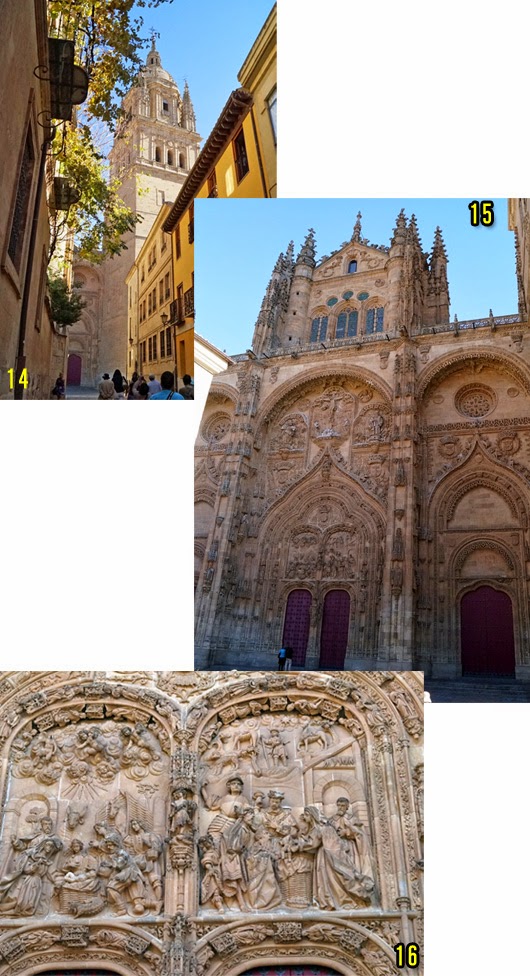
14:  The tower of Cathedral. It is romanesque style in the 12-13th century.
15:  " Door of the pardon " of Cathedral. It is baroque style in the 15-18th century.
16:  Enlarged view of " Door of the pardon ".  It shows one scene of Jesus Christ's birth.


14: 新カテドラルの塔。12~13世紀のロマネスク様式。
15: 新カテドラルの「許しの扉」。15~18世紀のバロック様式。
16: 「許しの扉」の拡大。イエス生誕の場面。


The north side of Cathedral

< 9.  The north side of Cathedral >
< 9. カテドラルの北側 >

On the next time, I introduce Avilla of a fortress city.

次回は、要塞都市アビラを紹介します。


20141222

Traveling to Spain and Portugal 29: Scenery from a car window, northern Spain and Portugal

スペインとポルトガルを巡る旅 29: 車窓から4、ポルトガルとスペイン北部


Upstream of Rio Douro near Porto, about 15:00, October 20

< 1.  Upstream of Rio Douro near Porto, about 15:00, October 20 >
< 1. ポルト近くのドウロ川上流、15時頃、10月20日 >

I introduce the scenery of Portugal and northern Spain today.
We traveled through from Evora of Portugal to Santiago de Compostela of Spain.
I took the most of these photos from my bus window.

ポルトガルのエヴォラからスペインのサンティアゴ・デ・コンポステーラまで縦断しました。
写真のほとんどはバスの車窓から撮ったものです。


map of our sightseeing route

< 2.  map of our sightseeing route >
< 2. 走行地図 >
This time, from October 18 to 21,we went north from number 11 of the map to 15, and returned to number 14 again.
今回は10月18日から21日にかけて、地図の番号11から15まで北上し、また14に戻った。


On the way to Lisbon from Evora

< 3.  On the way to Lisbon from Evora
< 3. エヴォラからリスボンまでの途中 >
Data:  About 18:30, October 18, from a bus.
The location on the map:  Between number 11 and 12.
データ: 18:30頃、10月18日、バスから。
地図上の位置:番号11から12の間。


On the way to Coimbra from Lisbon 

< 4.  On the way to Coimbra from Lisbon >
< 4. リスボンからコインブラまでの途中 >
Date:  From 9:00 to 11:00, October 20, from a bus.
The location on the map:  Between number 12 and 13.
データ:9~10時台、10月20日、バスから。
地図上の位置:番号12から13の間。


Upstream of Rio Douro near Porto

< 5. Upstream of Rio Douro near Porto >
< 5. ポルト近くのドウロ川上流 >
Date:  About 15:00, October 20, from a bus.
The location on the map:  Near the number 14.
データ:15時頃、10月20日、バスから。
地図上の位置:番号14の近く。


On the way to Santiago de Compostela from Porto 

< 6.  On the way to Santiago de Compostela from Porto >
< 6. ポルトからサンティアゴ・デ・コンポステーラまでの途中 >
Data:  8:30- 10:00, October 21, from a bus.
The location on the map:  Between number 14 and 15.
We often saw hazed scenery that could not see in Spain, because of wet by being near the Atlantic Ocean coast.

データ:8:30~10:00、10月21日、バスから。
地図上の位置:番号14から15の間。

太平洋岸の為か湿潤で、スペインでは見なかったもやがかかっていた。


About the view of private house and ancient city
As for the scenery along some highways that we ran through, the landscape clearly changed at the dividing line of Lisbon.
In the southern part from Lisbon, plains and gentle grassy plain spread out, and the private houses were relatively big and sparsely.
In the northern part from Lisbon, the hills that were covered by forest spread out, and the private houses scattered widely in the hillside and the hollow.
This is different from the town that was located on the upper part of the hill in the hilly areas of Spain.
The scenery of northern Portugal resembles the mountain village of Japan.

On the other hand, Elvas, Evora, Lisbon, Coimbra, Porto, Portugal's city where we visited had filled the hill with buildings all.
All these developed from a fort of the hilltop, and three latter used a big river for southern defense and for the trade.
These cities are similar to the ancient city of Spain very much.
Compared to this, it is symbolic that that developed in a basin.
In other words, Reconquista (war with the southern enemy for eight centuries) made the scenery of many ancient cities.
But Santiago de Compostela seems to have not become so, because peace visited to it early
Iberian cityscape was born in this way, and because of stone building, it have been passed down for many centuries.


民家と古都の景観について
我々が走った幹線道路沿いでは、リスボンを境にして地形と景観は様変わりしていた。
リスボンから南部は平野やなだらかな草原が続き、民家は比較的大きく疎らに建っている。北部は森林に覆われた丘陵が続き、民家はその丘陵の斜面や窪地に広く散在している。
これは、スペイン丘陵地帯の町が丘の上方に集中しているのとは異なる。
ポルトガル北部の景観は日本の山間の村に似ている。
ポルトガルでは南部の大規模農家と北部の小農家の違いが顕著です。

一方、今回訪れたポルトガルの都市、エルヴァス、エヴォラ、リスボン、コインブラ、ポルトは丘を埋め尽くしている。
これらはすべて丘の頂上の城砦から発展したもので、後者三つは大河を南方の防御と交易に利用している。
これら都市はスペインの古都と非常に似ている。
これに比べ、サンティアゴ・デ・コンポステーラが盆地で発展したことは象徴的です。
つまり、レコンキスタ(8世紀間続いた南方の敵との戦争)が多くの古都の景観を造った。
一方、早く平和が訪れた地域(サンティアゴ・デ・コンポステーラ)ではそうとはならなかったのだろう。
こうしてイベリアの都市景観が生まれ、石造建築ゆえ、今に引き継がれて来たのだろう。
このことが日本の都市景観と大きく異なる違いなのかもしれない。


Vigo gulf 

< 7.  Vigo gulf >
< 7. ビーゴ湾 >
Data:   10:00- 11:00, October 21, lower photo is in a roadside restaurant.
The location on the map:  Between number 14 and 15.

In this trip, the sea that I saw was only at Barcerona and Vigo.
I felt easier in my mind when I saw a seascape, because of remembering Japanese sea.

データ:10時台、10月21日、下の写真はドライブインで降車して。
地図上の位置:番号14から15の間。

今回の旅行で、海を見たのはバルセロナとこのビーゴ湾だけでした。
海の景色を見るとホットする、瀬戸内海を思い出すのか。


The suburbs of Santiago de Compostela

< 8.  The suburbs of Santiago de Compostela >
< 8. サンティアゴ・デ・コンポステーラ近郊 >
Data:  About 11:30, October 21.
The location of the map:  Number 15.

Upper photo:  A view of Santiago de Compostela from Monte do Gozo.
Three towers are seen at the left distant place slightly.

Lower photo:  The suburbs of Monte do Gozo.

データ:11:30頃、10月21日.
地図中の位置:番号15。

上の写真: 歓喜の丘からサンティアゴ・デ・コンポステーラを臨む。
左端にカテドラルの三つの塔が小さく見える。

下の写真: 歓喜の丘付近。


On the way to Porto from Santiago de Compostela 

< 9.  On the way to Porto from Santiago de Compostela >
< 9. サンティアゴ・デ・コンポステーラからポルトへ戻る途中 >
Data: 16:30- 17:30, October 21, from a bus.
The location on the world:  Between number 15 and 14.
Our bus goes almost the same route toward the south.

Next time, I introduce other sightseeing of Spain.

データ:16:30~17:30、10月21日、バスから。
地図上の位置:番号15から14の間。
バスは概ね同じ道を南下している。

次回から、スペインの観光になります。