Showing posts with label Series:Went around Croatia and Slovenia. Show all posts

20160214

クロアチア・スロベニアを巡って 28: 古代ローマの宮殿スプリット 2


< 1.鐘楼からの眺め >


今日は、ディオクレティアヌス宮殿跡を観光します。
2015年9月4日に訪れました。


< 2.青銅の門と宮殿の地下 >
上の写真: 海に面した「青銅の門」(南の門)。
他の二枚の写真: ディオクレティアヌス皇帝の私邸の地下部分。


< 3.宮殿の中庭 >
上の写真: 宮殿の中央部にある中庭です。
私達は今、中央の建物の地下を通って来ました。

中央の写真: このスフインクス像は中庭の奥左側にあります。
これは皇帝がエジプト遠征で持ち帰ったものです。

下の写真: この鐘楼は、皇帝の霊廟跡に建てられた大聖堂の鐘楼です。
大聖堂は8世紀、鐘楼は16世紀に完成している。


< 4. 鐘楼 >

私にとって、これがスプリット観光で最も印象深いものでした。


< 5.鐘楼からの眺め >
下の写真: 東側を見ている。
ここは人口20万の都市です。


< 6. 前庭 >
上の写真: 鐘楼が覗いています。
ここは皇帝の私邸の前庭で中庭に続いており、この下が先ほどの地下部分です。
このコーラスは、クロアチアの伝統音楽クラパです。
素朴で素敵な男性合唱で、私はCDを買いました。
私の録画ではありませんが、どうぞ楽しんでください。
https://www.youtube.com/watch?v=ae0gQ78lBTE


< 7.宮殿と民家 >
上の写真: 鐘楼と八角形の大聖堂が見える。
手前にあるのは、宮殿跡で暮らしている人々の住居です。

下の写真: 金の門(北の門)。
もっとも古い形が残っているようです。


ディオクレティアヌス皇帝と宮殿
彼は3世紀、この地方(ダルマチアのサロナ)で生まれたローマの軍人皇帝です、
彼はローマ帝国を2分割し、キリスト教徒を迫害したことで知られている。
彼は自ら引退し、生まれ故郷に近いこの地に宮殿を造り、余生を過ごした。

7世紀になるとスラブ人が侵入し、この地方は破壊され、離散した一部の人が廃墟になったこの宮殿内に暮らすようになった。
その後、至るところ民家に改造されていった。
一部復興はされているが、全体としては雑然とした不思議な空間になっている。
したがって世界遺産にはなっていない。


< 8. 銀の門と青空市場 >
上の写真: 銀の門(東の門)の外側に広がる露天。

下右側の写真: 宮殿外の東側にある青空市場。
観光客と地元の人で賑わっていた。


< 9. 広場 >
宮殿内の広場。


次回に続きます。


20160210

Went around Croatia and Slovenia 27 : Ancient Roman palace in Split 1

クロアチア・スロベニアを巡って 27: 古代ローマの宮殿スプリット 1


< 1.  At break of day at Trogir >
< 1. トロギールの夜明け >

I introduce an ancient Roman palace from now on.
Today, I introduce the sceneries from the shore of our hotel and from our bus on the way.

これから古代ローマの宮殿を紹介します。
今日は、ホテルの海岸からの景観や途中の景観を紹介します。


< 2. Trogir >
< 2. トロギール >

Upper photo:  The Adriatic Sea near by Trogir.
The opposite bank is an island.

Lower photo:  Trogir is an ancient harbor city and the world heritage.
This history of Trogir was made by ancient Greece, the Roman Empire, and Venice.
Parson that wants to sightsee to Trogir can go to it by taxi.

上の写真: トロギール近くのアドリア海。
対岸は島です。

下の写真: 世界遺産の港湾都市トロギールが見える。
トロギールの歴史は、古代ギリシャ、古代ローマ、ヴェネツィアによって作られた。
私達はここを観光しませんでしたが、ホテル到着後、タクシーで行くことが出来ます。


< 3.  At the shore of our hotel at night >
< 3. 夜、ホテルの海岸で >

Upper photo:  I look over at Trogir from the shore.
Lower two photos:  There were full of people who were enjoying the cool evening breeze in the shore.

Our hotel was built in forest facing the sea, and MEDEENA.
This is a big building built during the socialist era and the facilities were old, but we were able to enjoy it enough.

上の写真: ホテルの海岸からトロギールの方を望む。
下二枚の写真: 海岸には夕涼みを楽しむ人々で賑わっていました。

私たちのホテルは、MEDEENAで海に面した森林に建っていました。
これは社会主義時代に建てられた大きな建物で設備は古いですが、十分に楽しめました。


< 4.  At break of day from the shore of our hotel >
< 4. ホテルの海岸の夜明け >

Upper photo:  I look over at Trogir.
Lower photo:  There were people enjoying sea bathing before 7:00 A.M. on September 4.

上の写真: トロギールの方向を望む。
下の写真: 9月4日の朝7時前でしたが、海水浴を楽しむ人々がいました。


< 5.  Views from the top floor of the hotel 1 >
< 5. ホテルの最上階からの眺め 1 >

I took their three pictures at Trogir and they are expanded in turn.
A tower located in the center of the lower picture is the bell tower of cathedral that is representative of Trogir.

三枚の写真はトロギールを撮ったもので、順番に拡大しています。
一番下の写真中央に見える塔が、トロギールを代表する大聖堂の鐘楼です。


< 6.  Views from the top floor of the hotel 2 >
< 6. ホテルの最上階からの眺め 2 >
I was sequentially taking their pictures along with turning the west at the same place.
The break of day was warm and quiet.

ホテルの同じ場所から順次、西側を撮りました。
暖かく静かな夜明けでした。


< 7.  On the way to Split >
< 7. スプリットへの道から >

Second photo from the top:  It is city remains Salona of the Roman Empire period, and the population in the golden age was 20,000 people.
Here is the birthplace of emperor Diocletianus who built his palace in Split.

上から二枚目の写真: ローマ時代の都市遺跡サロナで、最盛期は人口2万人が暮らした。
ここはスプリットに宮殿を建てたローマ皇帝ディオクレティアヌスの生誕地です。


< 8.  The palace remains in Split >
< 8. 宮殿跡スプリット >

Split is the greatest city in the Dalmatia district of southern Croatia.
The palace remains that we just are going into were built 1,700 years ago.

スプリットはクロアチア南部のダルマチア地方最大の都市です。
今から見学する所は、1700年前の宮殿跡です。


< 9.  We just enter Split
< 9. いよいよスプリットへ入場 >
Lower photo:  A reconstructed picture of the palace.
This palace became ruins once, and was sinking partly, but people came to live there afterwards.

This continues next time.

下の写真: 当時の宮殿の復元図。
この宮殿は一度廃墟になり一部沈下しているのですが、その後、人々が住むようになりました。


次回に続きます。


20160206

クロアチア・スロベニアを巡って 26: 傷痕の町モスタル 5


< 1. 「ネレトヴァの戦い」で破壊された橋 >

今日は、ボスニア・ヘルツェゴビナ紛争の背景に迫ります。
そこには民族と宗教の皮肉な歴史がありました。

はじめに
写真1は、 1943年の「ネレトヴァの戦い」で破壊され保存されている橋です。
この戦いはネレトヴァ川で行われた。
第二次世界大戦中、劣勢のパルチザンはドイツ軍との戦いで大きな犠牲を出しながら後退していた。
この戦いでチトー率いるパルチザンが全滅を免れたことで、同年の旧ユーゴに誕生につながった。


< 2. ボスニア・ヘルツェゴビナ紛争の傷跡 >

上の写真: スレブレニツァ虐殺記念碑の墓地。
1995年、セルビア勢力がスレブレニツァの町に侵入し制圧を終えると、ムスリマの男性を1週間ほどで即決処刑し、その数は約8000人に及んだ。
この時、国連平和維持軍はいたが無力な為、制止できなかった。

中央の写真: 当時の避難する人々。
下の写真: 当時のモスタル郊外の惨状。


< 3. 戦いの果てに >

上の写真: ボスニア・ヘルツェゴビナ紛争時のサラエボの惨状、セルビア勢力、国連平和維持軍。

中央の写真: 紛争前後におけるボスニア・ヘルツェゴビナ内の民族分布。
緑色はムスリマ(Bosniaks)、赤色はセルビア人、青色はクロアチア人(HRVATI)を示す。
黄色い点はモスタルを示す。
ムスリマへの壮絶な民族浄化は、その後の棲み分けを決めた。

下の写真: 現在のボスニア・ヘルツェゴビナは桃色のセルビア人と青色のムスリマとクロアチア人との連邦になっている。

悲劇の遠因、歴史の皮肉
この内戦では同じ南スラブ民族の三つの民族が戦ったが、敵味方の識別は宗教の違い、カソリックと正教会、イスラムでした。
最も残虐だったのは正教会勢力(セルビア人)で、その大統領は国際裁判所で戦争犯罪の公判中です。
村を焼かれ多くの青年が殺され追い出されたのはムスリマでした。
彼らは数百年前「ボスニア教会」と呼ばれる異端のキリスト教徒で迫害を逃れ、この地に移り住み、オスマン帝国の時代にイスラムに転じた。
やがて彼らは地主や富裕層になり、キリスト教徒であるクロアチア人やセルビア人を使役するようになった。

時は下り、南スラブ人の大連合を成し遂げた旧ユーゴ時代、初代大統領チトーは異なる宗派や民族の融和を図るために、人々の混住化を推進した。
そして平和な半世紀が過ぎた。
しかし、瑣末な意見の食い違いが生じ、やがて指導者の野望と民衆の疑心暗鬼が一体となって戦端が開かれると、一気に憎悪と不安が燎原の火のように広がっていった。

彼らは歴史的な怨念を互いに多少持ってはいたが、先日までは仲良く暮らしていたのです。


次回から、次の観光地を紹介します。


20160204

クロアチア・スロベニアを巡って 25: 傷痕の町モスタル 4


< 1.石橋は紛争で破壊された >

のどかな山間の町が一瞬にして地獄になったことがありました。
それはボスニア・ヘルツェゴビナを民族浄化一色に染めた紛争でした。


< 2. ネレトヴァ川と一本の道 >

上の二枚の写真: 下流側(南側)を望む。
川の左側(東側)に旧市街があり、ムスリマは旧市街を中心に川を挟んで住んでいた。
川の右側を平行に走る道(一番下の写真)を境にして、紛争時、クロアチア勢力がムスリマの街を攻め、分断するために石橋を破壊した(写真1)。

上から三番目の写真: 上流側(北側)を望む。
一番下の写真: 北側を望む。
右側にネレトヴァ川と旧市街があります。


< 3. 紛争によるモスタルの傷跡 >


ボスニア・ヘルツェゴビナ紛争(1992~1995年)について
この紛争は一連のユーゴ内戦(1991~2001年)で最大の被害、20万人の死者と250万人の難民・避難民を出した。

ユーゴ内戦は、旧ユーゴを構成する6つの共和国から独立を宣言する国が出たことが引き金になった。
独立の是非を巡って、それぞれの国内の民族と宗派が対立し、セルビアが主導権を握る旧ユーゴ連邦軍が介入し戦争は拡大した。
最初にスロベニアが10日間戦争で1991独立し、ついでクロアチアが内戦(1991~1995)を経て独立することになる。
このクロアチア内戦でクロアチア人とセルビア勢力が戦っていた。

ボスニア・ヘルツェゴビナでは主導権を持つムスリマとクロアチア人、セルビア人が共に暮らしていた。
ムスリマとクロアチア人が独立宣言を模索し始めると、それを阻止する為に国内のセルビア人と隣国のセルビア軍、旧ユーゴ連邦軍が戦端を開いた。

ところが分割案を巡ってクロアチア人とムスリマも対立した。
ムスリマは、それぞれ隣国から支援を受けるクロアチア勢力とセルビア勢力に攻められ苦境に陥った。
この時、凄惨な民族浄化が起きた。

やがて国連と多国籍軍が停戦に向けて動き、NATO軍によるセルビア勢力への空爆、そして米国の仲介によって紛争は終結した。
その後、難民流入と民族問題で南部のコソボ、マケドニアへと戦火は広がった。


次回、悲劇の背景に迫ります。


20160201

Went around Croatia and Slovenia 24 : Deeply scarred Town Mostar 3

クロアチア・スロベニアを巡って 24: 傷痕の町モスタル 3


< 1.  I look at the old city from a riverside restaurant of Neretva >
< 1.ネレトヴァ川沿いのレストランから旧市街を眺めた >

A sequel to the introduction of Mostar
モスタル紹介の続きです


< 2.  Views of Strai Most (old bridge) from both sides >
< 2. 両側から見た石橋 >

Upper photo:  A view from the yard of the mosque.
A large cross stands on the top of the mountain.
Lower photo:  A view from the riverside on the downstream side.
A man just is going to jump into the river from the top of the bridge.
Each time he gets money, he jumps.
There is the jumping event annually here.

上の写真: モスクの庭からの眺め。
山頂に大きな十字架が立っている。

下の写真: 下流側の川辺から。
橋の上の中央から男性が今にも飛び込もうとしている。
彼はお金を貰っては飛び込んでいる。
年一度、ここで飛び込みの大会があります。


< 3.  Visit to “Turkish house” in the old city >
< 3. 旧市街の「トルコの家」を訪ねて >

Upper photo:  The minaret that we climbed can be seen.
Central photo:  When we were badly bunkered as we don’t find “Turkish house” at a map of a signboard, somebody called to us from behind and taught the pathway to it.
This kind man is the left side on the photo.
I think the map indicated not “Turkish house” but “Ottoman house”.

Lower photo:  “Turkish house”
When we arrived on it, we looked at only the entrance and had to return because our free time just was over.

上の写真: 私が登ったモスクのミナレットが見える。
中央の写真: 私達は看板の地図に「トルコの家」が見つからなくて困っていました。
すると後ろから声を掛けてくれる人がいて、道を教えてくれた。
その人が、写真左側の人でした。
看板には「トルコの家」ではなく「オットマン・ハウス」と表記されていたように思う。

下の写真: トルコの家。
辿り着いた時には戻る時間になっていて入口を覗くだけで引き返した。

We left Mostar and went to the next stage.

モスタルを出て、次の宿泊地に向かう。


< 4.  We left Mostar >
< 4. モスタルと別れる >

Lower photo:  I looked back toward Mostar located in the valley from the downstream side of Neretva.

下の写真: ネレトヴァ川の下流側から谷間にあるモスタルを振り返る。


< 5.  We parted from the Neretva >
< 5. ネレトヴァ川とも別れる >

We part from the Neretva at here, passed through the high plateau and went to the Adriatic Sea.
ここでネレトヴァ川とも別れ、高原を抜けてアドリア海岸へと向かう。


< 6. We passed through the high plateau >
< 6. 高原を抜けて >

This high plateau was a dry zone as a whole, but there also were lush green places.

On the next time, I introduce another scenery of Mostar, and Bosnian War.

高原は乾燥地帯だが、緑豊かな所もあった。

次回は、モスタルの新市街とボスニア・ヘルツェゴビナ紛争を紹介します。


20160125

Went around Croatia and Slovenia 23 : Deeply scarred Town Mostar 2

クロアチア・スロベニアを巡って 23: 傷痕の町モスタル 2          


< 1.  Old Bridge made by stones >
< 1.石橋「スタリ・モスト」 >

Today, we go for a walk in the old town of Mostar.
This old town is a town of Muslims.

今日は、モスタルの旧市街を歩きます。
旧市街はイスラム教徒の町です。          


< 2.  Go to the old town >
< 2. 旧市街に向かう >

Upper photo:  We just go out of the parking lot.
We left it at 11 A.M.

Central and lower Photos:  The street lined with souvenir shops.

上の写真: 駐車場から出るところです。
私達は11時に駐車場を出発しました。

中央と下の写真: 通りには土産物屋が並ぶ。


< 3.  Go to the Old bridge >
< 3.石橋に向かう >

Upper photo:  When I looked back, there were many traces of bullet on the store’s wall.
Lower photo:  The gate of the Old bridge.
You can see the top surface of the bridge behind the gate.

This bridge was restored in 2004 after its old bridge was destroyed by a civil war in 1993.
This was reproduced in its original condition made in the 16th century.

上の写真: 振り返ると店舗の壁に銃弾の跡がありました。
下の写真: 石橋の門です。
門の向こうに階段状の橋の上面が見える。

この石橋は1993年の内戦で破壊された後、2004年に復元されたものです。
これは16世紀に造られた当時のままに再現された。


< 4.  Views from the top of the bridge >
< 4. 石橋の上から >

Upper photo:  Downstream side of Neretva river.
Central photo:  Old bazaar we are going to go from now is seen. 

Lower photo:  Upstream side of it.
The minaret of a mosque we are going to climb after this is seen in the center.

上の写真: ネレトヴァ川の下流側。
中央の写真: これから行く旧市街のオールド・バザールが見える。
下の写真: 上流側。
これから登るモスクのミナレットが中央に見える。


< 5.  The Old bazaar >
< 5.オールド・バザール >

Mostar had prospered in trade, because it was located on a caravan route that linked the Adriatic Sea and the inland.
Mostar led to the Dubrovnik and Kotor that I already introduced.
The Old bazaar was a craftsman town that many copper craftsmen, tanners and tailors lived in.
There was an oriental atmosphere here.

モスタルは内陸とアドリア海を結ぶキャラバン・ルートにあり、交易で栄えて来た。
既に紹介したドゥブロブニクやコトルに通じていた。
このオールド・バザールはかつて銅職人やなめし職人、仕立屋などが住んでいた職人街です。
ここにはオリエンタルな雰囲気が漂っていた。


< 6.  Arrived at the mosque  >
< 6. モスクに来ました  >

Upper photo:  We went into the yard of the mosque.
The central hexagonal building is intended for cleaning up hands and feet.
                                                                                                                    
Lower photo:  In front of the mosque.
This Koski Mehmed pasa Mosque made in the 16th century is famous for a beautiful prospect.

上の写真: モスクの庭内に入って来た。
中央の六角形の建物は手足を洗い清めるところです。

下の写真: いよいよモスクに入ります。
これは16世紀に建てられたコスキ・メフメドパシャ・モスクで、眺めが良いので有名です。


< 7. Inside the mosque >
< 7. モスクの中 >

Upper photo:  there are a hollow of wall “ mihrab”, and a step-like preacher's pew “ mimbar”.
Central photo:  The ceiling.
Lower photo:  The stairs inside the minaret.

上の写真: メッカを示す壁の窪み(ミフラーブ)と階段状の説教壇(ミンバル)が見える。
中央の写真: 天井。
下の写真: ミナレットの階段。


< 8.  A view from the top of the minaret >
< 8. ミナレットから見た石橋 >

It is a view of downstream side.
下流側を見ている。


< 9.  Views from the top of the minaret
< 9.ミナレットからの眺め >

Upper photo:  It is a view of upper streamside and the north side.
A spire on the left is a church near our parking lot.

Lower photo:  I look at the old town of the east side.

This continues next time.


上の写真: 上流側で、北側です。
左に見える尖塔は私達の駐車場横にある教会です。

下の写真: 東側の旧市街を見ています。


次回に続きます。


20160119

Went around Croatia and Slovenia 22: Deeply scarred Town Mostar


クロアチア・スロベニアを巡って 22: 傷痕の町モスタル 1


< 1.  Župa Svetog Petra i Pavla is a church in Mostar
< 1.モスタルの教会、Župa Svetog Petra i Pavla

Today, we go to the intermountain town in Bosnia and Herzegovina.
I introduce the scenery between coastal town Neum and the Mostar.

今日は、ボスニア・ヘルツェゴビナの山間の町に向かいます。
海沿いの町ネウムからモスタルまでの景観を紹介します。
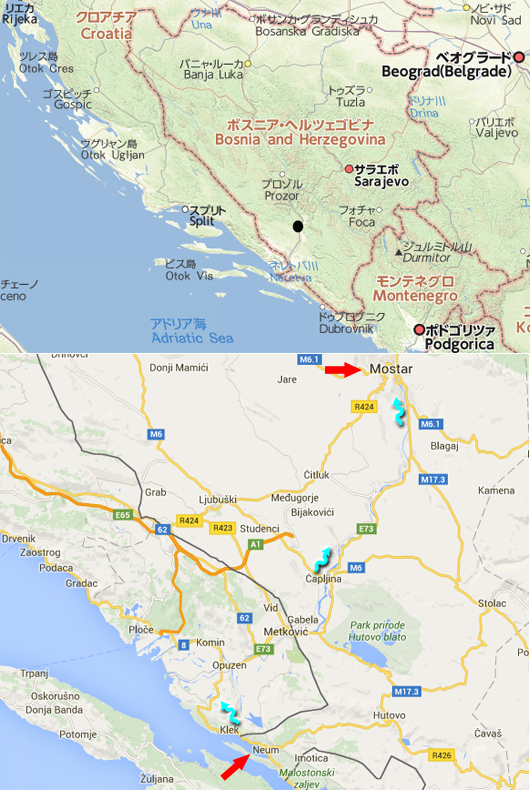


< 2.  Root maps >
< 2.地図 >

Upper map:  It shows Bosnia and Herzegovina.
A black point is the Mostar.

Lower map:  It shows the way to the Mostar from the Neum that we stayed in.
Red arrows show the two towns, and blue arrow shows the root.
The distance between the Mostar and the Neum is about 60 km.
We left at 9 A.M. on September 3, 2015, and arrived at 11 A.M.
It took much time, because we went through two checkpoints on the border.

上の地図:  ボスニア・ヘルツェゴビナを示す。
黒丸がモスタルです。

下の地図: ホテルのあるネウムからモスタルへの道を示す。
赤矢印が二つの町を示し、青矢印はそのルートを示す。
ネウムからモスタルまでは約60km。
2015年9月3日、9時に出発し11時に到着した。
時間がかかったのは、2箇所の国境検問所を通った為です。

About Mostar

1992-1995, Bosnia and Herzegovina was involved into Yugoslav Wars.
At this time, we have known the capital Sarajevo became the battlefield, and similar tragedy occurred in the Mostar, too.
Race of this nation consists of the most Muslims, subsequently a Croatian of the Christian, and a Serbian of the Greek Orthodox Church.
And this nation has a border with Croatia and Serbia.
By this, this Muslims suffered damage by ethnic cleansing by a Serbian at the time of Yugoslavia's collapse.

モスタルについて
1992~1995年、ボスニア・ヘルツェゴビナはユーゴ紛争に巻き込まれました。
この時、首都サラエボが戦場になったことはよく報道されたが、モスタルでも同様の悲劇が起こりました。
この国の民族は、イスラム教徒が一番多く、次いでキリスト教徒のクロアチア人、正教会のセルビア人で構成されている。
かつ、この国はクロアチアとセルビアと国境を接している。
このことにより、ユーゴスラビア崩壊時にイスラム教徒はセルビア人から民族浄化の被害を受けた。


< 3.  Sceneries between the Neum and downstream of Neretva >
< 3. ネウムからネレトヴァ川の下流まで >

Upper photo:  People had been enjoying a marine vacation.
Central photo:  As going through a mountain pass, I saw a monastery (?) on the hill.
Lower photo:  The plains that spread out downstream of Neretva river.

上の写真:  リゾートを楽しむ人々の姿が見える。
中央の写真: 峠を通過中、丘の上に修道院(?)が見えた。
下の写真:  ネレトヴァ川の河口に広がる平野部。


< 4.  We were coming down to the plains >
< 4. 平野部に降りていく >

There are lots of dry mountains in this area, but this place is filled with green.
乾燥した山間地が多い中にあって、ここは緑に溢れていた。


< 5.  Towns along the Neretva >
< 5. ネレトヴァ川沿いの街並み >

Upper photo:  I saw a mosque for the first time in this trip.
Graveyard of Islam is seen on the left side.

Central photo:  Neretva.
Lower photo:  Soccer seems popular.


上の写真: 今回の旅行で初めてモスクを見た。
左側に見えるのがイスラムの墓です。

中央の写真: ネレトヴァ川。
下の写真: サッカーが盛んなようです。


< 6.  We go into the mountain valley >
< 6. いよいよ川沿いに山間地へと上って行く >

People are growing grapes as hard as possible at the dry mountain area.

乾燥している山間地でも、人々はぶどうなどを精一杯栽培している。


< 7.  Near Mostar >
< 7. モスタルに近づいた >

Central photo:  Graveyard of Christianity system.
Lower photo:  We can look at innumerable traces of big bullet on the outer wall of the apartment.

This continues next time.

中央の写真: キリスト教系の墓地です。
下の写真:  アパートの外壁に大きな銃弾の跡が無数に見える。

次回に続きます。