鳥取旅行 1: 大山の雄姿
*1
I went around a mountain, seashore and a
hot spring of Tottori prefecture by car at May 21 and 22.
The main sightseeing
spot is Mt. Daisen, Misasa-Onsen (hot spring), Sanbutsu-ji (temple), Tottori
Port, Uradome Coast.
Today, I introduce grand
Mt. Daisen.
私は5月21、22日に鳥取県の山と海岸、温泉を車で巡りました。
主な観光地は、大山、三朝温泉、三徳山三佛寺、鳥取港、浦富海岸です。
今日は、大山の雄姿を紹介します。
< 2. map of Mt.
Daisen, the upper side of this map is north side >
< 2. 大山の地図、上部が北方向 >
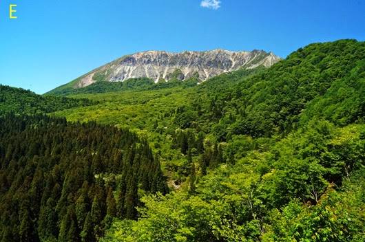
The alphabet of these
photos shows the shooting location on this map.
写真のアルファベットはこの地図の撮影地点を示している。
About Mt. Daisen
Mt. Daisen is
a volcanic mountain located in Tottori Prefecture, Japan.
This mountain has
an elevation of 1,729 meters, and the highest in the Chūgoku
region.
The central part was blown off by an
eruption that happened tens of thousands of years before, and an approximately
1 km of ridgeline of C type continues.
The width of the ridgeline is only 20-30
centimeters, and the left and right of the ridgeline are several hundred meters
of steep cliff, and traversing is prohibited.
The foot of the mountain
is about 35km in a north and south direction, and the snowcapped aspect from
the west is compared to Mount Fuji.
This has been the
subject of mountain worship from ancient times.
Today, this area attracts widespread
popularity as a national park, leisure on the plateaus, ski, and mountain
climbing.
大山について
大山は中国地方の最高峰(1729m)で、独立峰の火山です。
数万年前の噴火で中央部が吹き飛び、C型の稜線が1km程続いている。
その稜線の巾は数十㎝しかなく、左右は数百mの絶壁で絶えず崩落しており、縦走は禁止されている。
山の裾野は南北35kmあり、雪を被った西側からの姿は富士山に例えられる。
ここは古くから山岳信仰、現在は国立公園として高原のレジャー、登山、スキーで親しまれている。
今から約40年前、私はここに登山やスキーに幾たびか来ました。
稜線を怖々歩いたことが懐かしい。
その後、家族を連れて、蒜山高原には幾たびもドライブで訪れました。
ここは懐かしく、好きな山です。
< 3. views from south
side >
< 3. 南側からの雄姿 >
A: a view from Syouou S.A. of Chūgoku
Expressway.
B: a view from Kimendai (viewing platform) of Daisen
Parkway.
D: in the middle of Daisen Parkway.
A: 中国自動車道の勝央SAからの眺め。
B: 大山蒜山パークウェイの鬼女台(展望台)からの眺め。
D: 大山蒜山パークウェイより。
< 4. a view from Kagikake-Touge (viewing platform) >
< 4. 鍵掛峠(展望台)からの眺め >
< 5. a view from
Moto-Dani in the north side of Mt. Daisen >
< 5. 大山北側の元谷から >
I rose to Moto-Dani by walking for about 30
minutes from Daisen-Ji.
元谷へは大山寺側から徒歩で30分ほど昇って行きます。
< 6. views from the
north side and the west side >
< 6. 西側と北側からの眺め >
G: a view from Masumizu-Kougen. A view from
this west side is called Hoki-Fuji.
H, I: in the middle of till Daisen I.C. of Daisen Parkway.
G: 桝水高原からの眺め。この西側からの眺めが伯耆富士と呼ばれます。
H、I: 大山寺から大山IC間の道路から振り返った眺め。
Afterword
As the altitude of the
moving route became high, it became cool, and I could enjoy comfortable drive.
Blessed with splendid
weather, the colors of fresh green and flowers were just gorgeous.
On the next time, I
introduce other nature and scenery of Mt. Daisen.
あとがき
標高が高くなるにつれ涼しくなり快適なドライブを楽しめました。
すばらしい快晴に恵まれ、新緑と花々が目に鮮やかでした。
次回は、他の大山の自然と風景を紹介します。


No comments:
Post a Comment
どうぞご意見をお書き下さい。Please write an opinion.